
Carte topographique Waterford
Carte interactive
Cliquez sur la carte pour afficher l’altitude.
À propos de cette carte
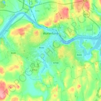
Nom : Carte topographique Waterford, altitude, relief.
Lieu : Waterford, County Waterford, Munster, Ireland (52.21024 -7.18695 52.27982 -7.03388)
Altitude moyenne : 33 m
Altitude minimum : -5 m
Altitude maximum : 106 m
Autres cartes topographiques
Cliquez sur une carte pour visualiser sa topographie, son altitude et son relief.
Pembrokestown
Pembrokestown, Waterford City Metropolitan District, County Waterford, Munster, X91 R6CA, Ireland
Altitude moyenne : 57 m
Lissaviron
Lissaviron, Annestown ED, The Municipal District of Comeragh, County Waterford, Munster, Ireland
Altitude moyenne : 60 m
Ring
Ring, The Municipal District of Dungarvan — Lismore, County Waterford, Munster, X35 E168, Ireland
Altitude moyenne : 48 m
Portlaw
Portlaw, The Municipal District of Comeragh, County Waterford, Munster, Ireland
Altitude moyenne : 51 m
Tramore Strand
Tramore Strand, Tramore, Waterford City Metropolitan District, County Waterford, Munster, Ireland
Altitude moyenne : 5 m
Kilmeaden
Kilmeaden, The Municipal District of Comeragh, County Waterford, Munster, X91 XP64, Ireland
Altitude moyenne : 65 m
Ballyduff
Ballyduff, The Municipal District of Dungarvan — Lismore, County Waterford, Munster, Ireland
Altitude moyenne : 187 m
Carrickphierish
Ireland > County Waterford > Waterford
Carrickphierish, Blackberry Fields, Gracedieu, Waterford, County Waterford, Munster, Ireland
Altitude moyenne : 42 m
Lismore
Lismore, The Municipal District of Dungarvan — Lismore, County Waterford, Munster, P51 VW44, Ireland
Altitude moyenne : 38 m
Mahon Falls
Mahon Falls, Mahon Falls Walk, Comeragh, The Municipal District of Comeragh, County Waterford, Munster, Ireland
Altitude moyenne : 575 m
Coolnasmear
Coolnasmear, Bohadoon, The Municipal District of Dungarvan — Lismore, County Waterford, Munster, X35 X859, Ireland
Altitude moyenne : 135 m
Cheekpoint
Ireland > County Waterford > Cheekpoint
Cheekpoint, Faithlegg, Waterford City Metropolitan District, County Waterford, Munster, Ireland
Altitude moyenne : 25 m
Carrigbrack
Carrigbrack, Knockaunbrandaun, The Municipal District of Comeragh, County Waterford, Munster, Ireland
Altitude moyenne : 436 m
Bog
Bog, Gardenmorris, The Municipal District of Comeragh, County Waterford, Munster, Ireland
Altitude moyenne : 62 m
Glendeish West
Glendeish West, Ballyin, The Municipal District of Dungarvan — Lismore, County Waterford, Munster, Ireland
Altitude moyenne : 215 m
Wyse Park
Wyse Park, Mount Sion, Waterford City Metropolitan District, County Waterford, Munster, Ireland
Altitude moyenne : 24 m
Mahon
Mahon, The Municipal District of Comeragh, County Waterford, Munster, Ireland
Altitude moyenne : 66 m
Passage East
Passage East, County Waterford, Munster, Ireland
Altitude moyenne : 28 m
Barravakeen
Barravakeen, Gurteen, The Municipal District of Comeragh, County Waterford, Munster, Ireland
Altitude moyenne : 294 m
Dungarvan
Dungarvan, The Municipal District of Dungarvan — Lismore, County Waterford, Munster, X35 V670, Ireland
Altitude moyenne : 30 m
Killerguile
Killerguile, Clonea, The Municipal District of Comeragh, County Waterford, Munster, Ireland
Altitude moyenne : 144 m
Landscape
Landscape, Glen, The Municipal District of Comeragh, County Waterford, Munster, Ireland
Altitude moyenne : 90 m
Fourmilewater
Fourmilewater, Ballymacarbry, The Municipal District of Comeragh, County Waterford, Munster, Ireland
Altitude moyenne : 99 m
Ballynamult
Ballynamult, The Municipal District of Dungarvan — Lismore, County Waterford, Munster, Ireland
Altitude moyenne : 170 m
River Nire
River Nire, The Municipal District of Dungarvan — Lismore, County Waterford, Munster, E91 D427, Ireland
Altitude moyenne : 224 m
Aglish
Aglish, Castlerichard, The Municipal District of Dungarvan — Lismore, County Waterford, Munster, Ireland
Altitude moyenne : 66 m
Colligan
Colligan, The Municipal District of Dungarvan — Lismore, County Waterford, Munster, X35 X859, Ireland
Altitude moyenne : 101 m
Cappoquin
Cappoquin, The Municipal District of Dungarvan — Lismore, County Waterford, Munster, Ireland
Altitude moyenne : 171 m
Ballymulalla West
Ballymulalla West, Keereen, The Municipal District of Dungarvan — Lismore, County Waterford, Munster, Ireland
Altitude moyenne : 90 m
Ballykilmurry
Ballykilmurry, Tinnasaggart, The Municipal District of Comeragh, County Waterford, Munster, Ireland
Altitude moyenne : 157 m
Kilwinny
Kilwinny, Tallow, The Municipal District of Dungarvan — Lismore, County Waterford, Munster, Ireland
Altitude moyenne : 45 m
Knockeen
Knockeen, The Municipal District of Comeragh, County Waterford, Munster, E91 D427, Ireland
Altitude moyenne : 264 m
The Municipal District of Dungarvan — Lismore
The Municipal District of Dungarvan — Lismore, County Waterford, Munster, Ireland
Altitude moyenne : 120 m
Waterford City Metropolitan District
Waterford City Metropolitan District, County Waterford, Munster, Ireland
Altitude moyenne : 29 m
Broemountain
Broemountain, The Municipal District of Dungarvan — Lismore, County Waterford, Munster, Ireland
Altitude moyenne : 280 m
Dunhill
Dunhill, The Municipal District of Comeragh, County Waterford, Munster, Ireland
Altitude moyenne : 77 m
Ballymacarbry
Ballymacarbry, The Municipal District of Comeragh, County Waterford, Munster, Ireland
Altitude moyenne : 145 m
Kilgobnet
Ireland > County Waterford > Kilgobnet
Kilgobnet, Colligan, The Municipal District of Dungarvan — Lismore, County Waterford, Munster, Ireland
Altitude moyenne : 96 m
Newcastle
Newcastle, The Municipal District of Comeragh, County Waterford, Munster, Ireland
Altitude moyenne : 98 m
Monatray East
Monatray East, Kinsalebeg, The Municipal District of Dungarvan — Lismore, County Waterford, Munster, Ireland
Altitude moyenne : 23 m
Millstreet
Millstreet, Ballynamult, The Municipal District of Dungarvan — Lismore, County Waterford, Munster, Ireland
Altitude moyenne : 112 m
Monvoy
Monvoy, Tramore, Waterford City Metropolitan District, County Waterford, Munster, Ireland
Altitude moyenne : 53 m
Portally
Portally, Rathmoylan, Waterford City Metropolitan District, County Waterford, Munster, Ireland
Altitude moyenne : 26 m
Ballyvoony
Ballyvoony, Carrigcastle, The Municipal District of Comeragh, County Waterford, Munster, Ireland
Altitude moyenne : 43 m
Carrigaun (Hely)
Carrigaun (Hely), Modelligo, The Municipal District of Dungarvan — Lismore, County Waterford, Munster, Ireland
Altitude moyenne : 98 m
Ballyheadon
Ballyheadon, Annestown ED, The Municipal District of Comeragh, County Waterford, Munster, Ireland
Altitude moyenne : 42 m
Ballymacart
Ballymacart, The Municipal District of Dungarvan — Lismore, County Waterford, Munster, Ireland
Altitude moyenne : 74 m
Brownstown
Brownstown, Rathmoylan, Waterford City Metropolitan District, County Waterford, Munster, Ireland
Altitude moyenne : 15 m