
Faire un don
Équipez-vous pour votre prochaine aventure :
En tant que Partenaire Amazon, ce site perçoit une commission sur les achats éligibles sans surcoût pour vous.
Carte topographique Castle Park
Cliquez sur la carte pour afficher l’altitude.
Faire un don
Équipez-vous pour votre prochaine aventure :
En tant que Partenaire Amazon, ce site perçoit une commission sur les achats éligibles sans surcoût pour vous.
Castle Park
The main objection to this plan came from the independent traders who did not wish to relocate because they felt that the proposed new shopping area was 'off the beaten track'. This objection was not unreasonable, as in its pre-war topography Bristol had a long shopping axis that started at Stapleton Road to the east, passed through Old Market into Castle Street, Wine Street, and the City Markets, and then via The Centre and Park Street to Queens Road and Whiteladies Road. Moving the central shopping area would break this axis. There was also concern about the serious negative social and economic impacts of 'sterilising' such a large area in the centre of the city. However, when the Bristol Retail Traders Federation, representing the small traders, produced a poll showing that 13,000 people wished to retain the shopping centre on its current site whereas only 400 preferred to see it moved, the local Labour party dismissed the poll describing it as 'undemocratic' and comparing the Federation's methods to those of Hitler.
Faire un don
Équipez-vous pour votre prochaine aventure :
En tant que Partenaire Amazon, ce site perçoit une commission sur les achats éligibles sans surcoût pour vous.
À propos de cette carte
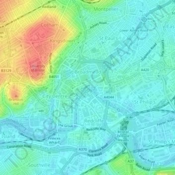
Nom : Carte topographique Castle Park, altitude, relief.
Altitude moyenne : 26 m
Altitude minimum : 6 m
Altitude maximum : 86 m
Faire un don
Équipez-vous pour votre prochaine aventure :
En tant que Partenaire Amazon, ce site perçoit une commission sur les achats éligibles sans surcoût pour vous.
Autres cartes topographiques
Cliquez sur une carte pour visualiser sa topographie, son altitude et son relief.
Faire un don
Équipez-vous pour votre prochaine aventure :
En tant que Partenaire Amazon, ce site perçoit une commission sur les achats éligibles sans surcoût pour vous.
Faire un don
Équipez-vous pour votre prochaine aventure :
En tant que Partenaire Amazon, ce site perçoit une commission sur les achats éligibles sans surcoût pour vous.