Géolocaliser

Carte topographique Hull

Carte interactive

Cliquez sur la carte pour afficher l’altitude.

À propos de cette carte

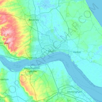
Nom : Carte topographique Hull, altitude, relief.

Lieu : Hull, Kingston upon Hull, England, HU1 3RJ, United Kingdom (53.58357 -0.49948 53.90357 -0.17948)

Altitude moyenne : 21 m

Altitude minimum : -4 m

Altitude maximum : 168 m

Kingston upon Hull is on the northern bank of the Humber Estuary. The city centre is west of the River Hull and close to the Humber. The city is built upon alluvial and glacial deposits which overlie chalk rocks but the underlying chalk has no influence on the topography. The land within the city is generally very flat and is only 2 to 4 metres (6.5 to 13 ft) above sea level. Because of the relative flatness of the site there are few physical constraints upon building and many open areas are the subject of pressures to build.

Wikipedia (CC-BY-SA 3.0)

Autres cartes topographiques

Cliquez sur une carte pour visualiser sa topographie, son altitude et son relief.

Sutton

United Kingdom > England > Kingston upon Hull > Sutton

Sutton, Kingston upon Hull, Yorkshire and the Humber, England, HU7 4UF, United Kingdom

Altitude moyenne : 3 m