
Carte topographique Armagh
Carte interactive
Cliquez sur la carte pour afficher l’altitude.
À propos de cette carte
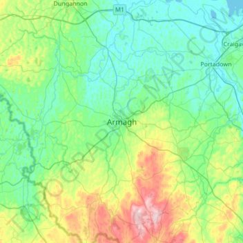
Nom : Carte topographique Armagh, altitude, relief.
Altitude moyenne : 85 m
Altitude minimum : 10 m
Altitude maximum : 359 m
Autres cartes topographiques
Cliquez sur une carte pour visualiser sa topographie, son altitude et son relief.
Killylea
United Kingdom > Northern Ireland > County Armagh > Armagh
Killylea, Armagh, County Armagh, Northern Ireland, BT60 4LN, United Kingdom
Altitude moyenne : 73 m