
Carte topographique Sierra Vista
Carte interactive
Cliquez sur la carte pour afficher l’altitude.
À propos de cette carte
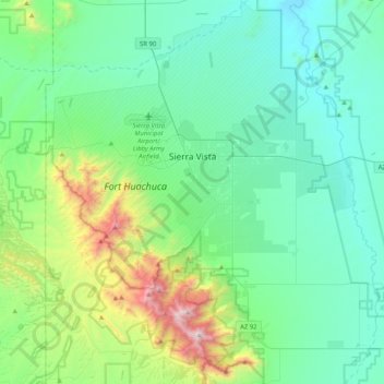
Nom : Carte topographique Sierra Vista, altitude, relief.
Lieu : Sierra Vista, Cochise County, Arizona, United States (31.34778 -110.44915 31.69604 -110.09806)
Altitude moyenne : 1’507 m
Altitude minimum : 1’182 m
Altitude maximum : 2’861 m
In the Köppen climate classification system, Sierra Vista falls within the typical cold semi-arid climate (BSk) of mid-altitude Arizona. Fall and spring, like most other parts of Arizona, are very dry. Winters are cool to cold with frosts which can occasionally be hard freezes; frost can be expected to stop in mid- to late April. Spring, like fall, spends about half of itself within the frost season. Summer starts off dry, but progressively gets wetter as the monsoon season approaches. The city has a fairly stable climate with very little humidity. However, the North American Monsoon can bring torrential rains during the months of July and August and will produce almost half the yearly rainfall in just those two months alone. Due to the dry climate the rest of the year and the city's high elevation, daily winter low temperatures range from 20 to 30 °F (−6.7 to −1.1 °C) on average and up to 50 °F (10.0 °C) on rare occasions when moist fronts bring warm air from the Gulf of California. Snow is not a common sight on the streets of Sierra Vista though some years the city can receive several inches of snow and other years it will receive none. However, a snow-capped Miller Peak and Carr Peak in the Huachuca Mountains is a common sight for four to five months every year.
Autres cartes topographiques
Cliquez sur une carte pour visualiser sa topographie, son altitude et son relief.
Bisbee
United States > Arizona > Cochise County
Bisbee, Cochise County, Arizona, United States
Altitude moyenne : 1’676 m
Sierra Vista Estates
United States > Arizona > Cochise County > Sierra Vista
Sierra Vista Estates, Sierra Vista, Cochise County, Arizona, 85650, United States
Altitude moyenne : 1’429 m
Whetstone
United States > Arizona > Cochise County
Whetstone, Cochise County, Arizona, United States
Altitude moyenne : 1’342 m
Little Rincon Mountains
United States > Arizona > Cochise County
Little Rincon Mountains, Cochise County, Arizona, United States
Altitude moyenne : 1’331 m
Kartchner Caverns State Park
United States > Arizona > Cochise County > Benson
Kartchner Caverns State Park, Benson, Cochise County, Arizona, 85602, United States
Altitude moyenne : 1’432 m
Bakerville
United States > Arizona > Cochise County > Bisbee > Warren
Bakerville, Warren, Bisbee, Cochise County, Arizona, 85603, United States
Altitude moyenne : 1’579 m
Dragoon
United States > Arizona > Cochise County
Dragoon, Cochise County, Arizona, 85609, United States
Altitude moyenne : 1’422 m
Miller Peak
United States > Arizona > Cochise County > Sierra Vista
Miller Peak, Sierra Vista, Cochise County, Arizona, United States
Altitude moyenne : 2’402 m
Willcox
United States > Arizona > Cochise County
Willcox, Cochise County, Arizona, 85643, United States
Altitude moyenne : 1’274 m
St. David
United States > Arizona > Cochise County
St. David, Cochise County, Arizona, 85630, United States
Altitude moyenne : 1’138 m
Fisher Hills
United States > Arizona > Cochise County
Fisher Hills, Cochise County, Arizona, United States
Altitude moyenne : 1’237 m
Douglas
United States > Arizona > Cochise County
Douglas, Cochise County, Arizona, United States
Altitude moyenne : 1’265 m
Hereford
United States > Arizona > Cochise County
Hereford, Cochise County, Arizona, United States
Altitude moyenne : 1’293 m
Tombstone
United States > Arizona > Cochise County
Tombstone, Cochise County, Arizona, 85638, United States
Altitude moyenne : 1’364 m
Chiricahua National Monument
United States > Arizona > Cochise County
Chiricahua National Monument, Cochise County, Arizona, United States
Altitude moyenne : 1’861 m
Whetstone
United States > Arizona > Cochise County
Whetstone, Cochise County, Arizona, United States
Altitude moyenne : 1’324 m
Huachuca City
United States > Arizona > Cochise County
Huachuca City, Cochise County, Arizona, 85616, United States
Altitude moyenne : 1’329 m
Huachuca Terrace
United States > Arizona > Cochise County > Bisbee
Huachuca Terrace, Bisbee, Cochise County, Arizona, 85603, United States
Altitude moyenne : 1’524 m
Fry
United States > Arizona > Cochise County > Sierra Vista
Fry, Sierra Vista, Cochise County, Arizona, 85636, United States
Altitude moyenne : 1’405 m
Tombstone
United States > Arizona > Cochise County > Tombstone > Tombstone
Tombstone, Cochise County, Arizona, 85638, United States
Altitude moyenne : 1’373 m
Pearce
United States > Arizona > Cochise County
Pearce, Cochise County, Arizona, United States
Altitude moyenne : 1’351 m
Douglas
United States > Arizona > Cochise County > Douglas > Douglas
Douglas, Cochise County, Arizona, 85607-6261, United States
Altitude moyenne : 1’233 m
Kartchner Caverns
United States > Arizona > Cochise County
Kartchner Caverns, Foothills Loop Trail, Cochise County, Arizona, United States
Altitude moyenne : 1’440 m
Chiricahua
United States > Arizona > Cochise County > Chiricahua
Chiricahua, Cochise County, Arizona, United States
Altitude moyenne : 1’429 m
Paradise
United States > Arizona > Cochise County > Paradise
Paradise, Cochise County, Arizona, United States
Altitude moyenne : 1’783 m
Apache
United States > Arizona > Cochise County > Apache
Apache, Cochise County, Arizona, United States
Altitude moyenne : 1’340 m
Bledsoe
United States > Arizona > Cochise County > Sierra Vista > Bledsoe
Bledsoe, Sierra Vista, Cochise County, Arizona, United States
Altitude moyenne : 1’858 m
Benson
United States > Arizona > Cochise County
Benson, Cochise County, Arizona, United States
Altitude moyenne : 1’247 m
Sierra Vista Southeast
United States > Arizona > Cochise County
Sierra Vista Southeast, Cochise County, Arizona, United States
Altitude moyenne : 1’503 m
Miracle Valley
United States > Arizona > Cochise County
Miracle Valley, Cochise County, Arizona, 85615, United States
Altitude moyenne : 1’329 m
Elfrida
United States > Arizona > Cochise County
Elfrida, Cochise County, Arizona, United States
Altitude moyenne : 1’266 m