Faire un don
Équipez-vous pour votre prochaine aventure :
En tant que Partenaire Amazon, ce site perçoit une commission sur les achats éligibles sans surcoût pour vous.
Carte topographique Canberra
Cliquez sur la carte pour afficher l’altitude.
Faire un don
Équipez-vous pour votre prochaine aventure :
En tant que Partenaire Amazon, ce site perçoit une commission sur les achats éligibles sans surcoût pour vous.
Canberra
The area chosen for the capital had been inhabited by Indigenous Australians for up to 21,000 years, with the principal group being the Ngunnawal people. European settlement commenced in the first half of the 19th century, as evidenced by surviving landmarks such as St John's Anglican Church and Blundells Cottage. On 1 January 1901, federation of the colonies of Australia was achieved. Following a long dispute over whether Sydney or Melbourne should be the national capital, a compromise was reached: the new capital would be built in New South Wales, so long as it was at least 100 miles (160 km) from Sydney. The capital city was founded and formally named as Canberra in 1913. A blueprint by American architects Walter Burley Griffin and Marion Mahony Griffin was selected after an international design contest, and construction commenced in 1913. Unusual among Australian cities, it is an entirely planned city. The Griffins' plan featured geometric motifs and was centred on axes aligned with significant topographical landmarks such as Black Mountain, Mount Ainslie, Capital Hill and City Hill. Canberra's mountainous location makes it the only mainland Australian city where snow-capped mountains can be seen in winter; although snow in the city itself is uncommon.
Faire un don
Équipez-vous pour votre prochaine aventure :
En tant que Partenaire Amazon, ce site perçoit une commission sur les achats éligibles sans surcoût pour vous.
À propos de cette carte
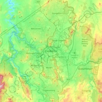
Nom : Carte topographique Canberra, altitude, relief.
Altitude moyenne : 638 m
Altitude minimum : 395 m
Altitude maximum : 1’238 m
Faire un don
Équipez-vous pour votre prochaine aventure :
En tant que Partenaire Amazon, ce site perçoit une commission sur les achats éligibles sans surcoût pour vous.
Autres cartes topographiques
Cliquez sur une carte pour visualiser sa topographie, son altitude et son relief.
Sydney
Sydney's topography is characterized by a diverse landscape that seamlessly blends coastal features with inland plateaus. The city is divided into two primary regions: the relatively flat Cumberland Plain to the south and west of Sydney Harbour, and the elevated Hornsby Plateau to the north. The Cumberland…
Altitude moyenne : 53 m
City of Melbourne
Melbourne's topography is characterized by a diverse landscape that transitions from flat coastal plains to rolling hills and mountainous regions. The city is situated at the northern end of Port Phillip Bay, where the terrain is predominantly flat, facilitating urban development. As one moves eastward, the…
Altitude moyenne : 18 m
Victoria
Victoria, Australia, exhibits a remarkably varied topography shaped by the Great Dividing Range, which forms a west-to-east spine across the state. In the northeast, the Victorian Alps rise to the state’s highest point, Mount Bogong at 1,986 meters, amid deep valleys and snow-capped ridges, while westward,…
Altitude moyenne : 179 m
Queensland
Queensland's topography is characterized by a diverse landscape that includes coastal plains, mountain ranges, plateaus, and expansive inland areas. The Great Dividing Range runs parallel to the state's eastern coast, forming a series of mountain ranges, plateaus, and upland areas. This range influences the…
Altitude moyenne : 122 m
Faire un don
Équipez-vous pour votre prochaine aventure :
En tant que Partenaire Amazon, ce site perçoit une commission sur les achats éligibles sans surcoût pour vous.
New South Wales
New South Wales (NSW), located on Australia's eastern seaboard, boasts a diverse topography that significantly influences its landscapes and ecosystems. The state's eastern edge is dominated by a narrow coastal plain, featuring regions such as the Illawarra and Shoalhaven near Nowra, characterized by rolling…
Altitude moyenne : 154 m
Western Australia
Because the only mountain-building since then has been of the Stirling Range with the rifting from Antarctica, the land is extremely eroded and ancient, with no part of the state above 1,245 metres (4,085 ft) AHD (at Mount Meharry in the Hamersley Range of the Pilbara region). Most of the state is a low…
Altitude moyenne : 194 m
Tasmania
The most mountainous region is the Central Highlands area, which covers most of the central western parts of the state. The Midlands located in the central east, is fairly flat, and is predominantly used for agriculture, although farming activity is scattered throughout the state. Tasmania's tallest mountain…
Altitude moyenne : 220 m
Faire un don
Équipez-vous pour votre prochaine aventure :
En tant que Partenaire Amazon, ce site perçoit une commission sur les achats éligibles sans surcoût pour vous.
Melbourne
Melbourne is also prone to isolated convective showers forming when a cold pool crosses the state, especially if there is considerable daytime heating. These showers are often heavy and can include hail, squalls, and significant drops in temperature, but they often pass through very quickly with a rapid…
Altitude moyenne : 185 m
Great Dividing Range
The Great Dividing Range, also known as the East Australian Cordillera or the Eastern Highlands, is a cordillera system in eastern Australia consisting of an expansive collection of mountain ranges, plateaus and rolling hills, that runs roughly parallel to the east coast of Australia and forms the…
Altitude moyenne : 117 m
Faire un don
Équipez-vous pour votre prochaine aventure :
En tant que Partenaire Amazon, ce site perçoit une commission sur les achats éligibles sans surcoût pour vous.
Faire un don
Équipez-vous pour votre prochaine aventure :
En tant que Partenaire Amazon, ce site perçoit une commission sur les achats éligibles sans surcoût pour vous.
Sunshine Coast Regional
The Sunshine Coast Regional area in Queensland, Australia, features a diverse topography that ranges from coastal plains to rugged hinterlands. Along the coastline, the terrain is predominantly flat, with average elevations around 20 meters (66 feet) above sea level. Inland, the landscape transitions to…
Altitude moyenne : 56 m
City of Brisbane
Brisbane's topography is characterized by a series of hills and ranges that define its landscape. The city is situated on a low-lying floodplain, with the Brisbane River meandering through its heart, creating a winding course with many steep curves from the southwest to its mouth at Moreton Bay in the east.…
Altitude moyenne : 71 m
Faire un don
Équipez-vous pour votre prochaine aventure :
En tant que Partenaire Amazon, ce site perçoit une commission sur les achats éligibles sans surcoût pour vous.
Faire un don
Équipez-vous pour votre prochaine aventure :
En tant que Partenaire Amazon, ce site perçoit une commission sur les achats éligibles sans surcoût pour vous.
Orange
Orange is a city in the Central Tablelands region of New South Wales, Australia. It is 254 km (158 mi) west of the state capital, Sydney [206 km (128 mi) on a great circle], at an altitude of 862 metres (2,828 ft). Orange had an estimated urban population of 40,493 as of June 2018 making the city a significant…
Altitude moyenne : 852 m
Faire un don
Équipez-vous pour votre prochaine aventure :
En tant que Partenaire Amazon, ce site perçoit une commission sur les achats éligibles sans surcoût pour vous.
Byron Bay
Byron Bay, located in northeastern New South Wales, Australia, is characterized by diverse topography shaped by its geological history. The town is part of the erosion caldera of the ancient Tweed Volcano, which erupted approximately 23 million years ago, resulting in the rich volcanic soils that define the…
Altitude moyenne : 7 m
Goulburn
Owing to its elevation, Goulburn has an oceanic climate (Cfb) with warm summers and cool winters; with a high diurnal range. Its climate is variable much of the year, though generally dry with maximum temperatures ranging from 11.8 °C (53.2 °F) in July to 28.3 °C (82.9 °F) in January. Rainfall is…
Altitude moyenne : 666 m
Faire un don
Équipez-vous pour votre prochaine aventure :
En tant que Partenaire Amazon, ce site perçoit une commission sur les achats éligibles sans surcoût pour vous.
Faire un don
Équipez-vous pour votre prochaine aventure :
En tant que Partenaire Amazon, ce site perçoit une commission sur les achats éligibles sans surcoût pour vous.
Faire un don
Équipez-vous pour votre prochaine aventure :
En tant que Partenaire Amazon, ce site perçoit une commission sur les achats éligibles sans surcoût pour vous.
Faire un don
Équipez-vous pour votre prochaine aventure :
En tant que Partenaire Amazon, ce site perçoit une commission sur les achats éligibles sans surcoût pour vous.
Leura
Leura's elevation of 985 metres (3,232 ft) AHD leads to occasional snowfall in winter and a climate that reflects all four seasons distinctly.
Altitude moyenne : 880 m
Faire un don
Équipez-vous pour votre prochaine aventure :
En tant que Partenaire Amazon, ce site perçoit une commission sur les achats éligibles sans surcoût pour vous.
Lama Lama National Park (Cape York Peninsula Aboriginal Land)
Altitude moyenne : 86 m
Faire un don
Équipez-vous pour votre prochaine aventure :
En tant que Partenaire Amazon, ce site perçoit une commission sur les achats éligibles sans surcoût pour vous.
Faire un don
Équipez-vous pour votre prochaine aventure :
En tant que Partenaire Amazon, ce site perçoit une commission sur les achats éligibles sans surcoût pour vous.
Faire un don
Équipez-vous pour votre prochaine aventure :
En tant que Partenaire Amazon, ce site perçoit une commission sur les achats éligibles sans surcoût pour vous.
Faire un don
Équipez-vous pour votre prochaine aventure :
En tant que Partenaire Amazon, ce site perçoit une commission sur les achats éligibles sans surcoût pour vous.
Roma
Roma experiences a humid subtropical climate (Köppen: Cfa, Trewartha: Cfal); with hot summers with moderate rains; warm to hot, relatively dry springs and autumns; and mild, dry winters. Its location on the far south of the Carnarvon Range at an elevation of 299 metres above sea level means that it is cooler…
Altitude moyenne : 315 m
Faire un don
Équipez-vous pour votre prochaine aventure :
En tant que Partenaire Amazon, ce site perçoit une commission sur les achats éligibles sans surcoût pour vous.
Faire un don
Équipez-vous pour votre prochaine aventure :
En tant que Partenaire Amazon, ce site perçoit une commission sur les achats éligibles sans surcoût pour vous.
Faire un don
Équipez-vous pour votre prochaine aventure :
En tant que Partenaire Amazon, ce site perçoit une commission sur les achats éligibles sans surcoût pour vous.
Tasmania
The most mountainous region is the Central Highlands area, which covers most of the central western parts of the state. The Midlands located in the central east, is fairly flat, and is predominantly used for agriculture, although farming activity is scattered throughout the state. Tasmania's tallest mountain…
Altitude moyenne : 6 m
Faire un don
Équipez-vous pour votre prochaine aventure :
En tant que Partenaire Amazon, ce site perçoit une commission sur les achats éligibles sans surcoût pour vous.
Castlemaine
The Castlemaine goldfields' legendary prosperity raised expectations of Castlemaine becoming Victoria's second city. That is reflected in imposing buildings erected in the town's first few years. Though the rich alluvial diggings were largely exhausted within 15–20 years causing the town's population to…
Altitude moyenne : 319 m
Faire un don
Équipez-vous pour votre prochaine aventure :
En tant que Partenaire Amazon, ce site perçoit une commission sur les achats éligibles sans surcoût pour vous.
Faire un don
Équipez-vous pour votre prochaine aventure :
En tant que Partenaire Amazon, ce site perçoit une commission sur les achats éligibles sans surcoût pour vous.
Groote Eylandt
Groote Eylandt lies about 50 kilometres (25 nautical miles) offshore from the Northern Territory mainland (i.e. the east coast of Arnhem Land), about 630 kilometres (390 mi) from Darwin, opposite Blue Mud Bay. The island measures about 50 kilometres (31 mi) from east to west and 60 kilometres (37 mi) from…
Altitude moyenne : 18 m
Faire un don
Équipez-vous pour votre prochaine aventure :
En tant que Partenaire Amazon, ce site perçoit une commission sur les achats éligibles sans surcoût pour vous.
Faire un don
Équipez-vous pour votre prochaine aventure :
En tant que Partenaire Amazon, ce site perçoit une commission sur les achats éligibles sans surcoût pour vous.
Blue Mountains
A sandstone plateau dominated by a landscape of endless eucalyptus forests, the Blue Mountains are located at the top of a 470-million-year-old quartzite. In the Permian period, a shallow sea covered the region, when rivers brought shales, siltstones and mudstones. Then during the Mesozoic period, rivers…
Altitude moyenne : 566 m
Faire un don
Équipez-vous pour votre prochaine aventure :
En tant que Partenaire Amazon, ce site perçoit une commission sur les achats éligibles sans surcoût pour vous.
