Carte topographique Nubra
Carte interactive
Cliquez sur la carte pour afficher l’altitude.
À propos de cette carte
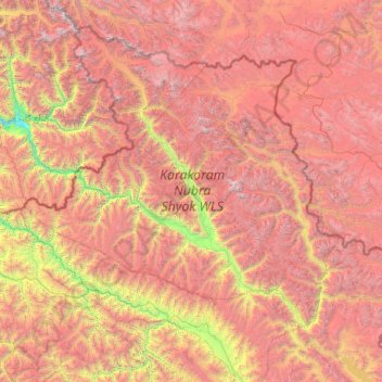
Nom : Carte topographique Nubra, altitude, relief.
Lieu : Nubra, Leh district, Ladakh, 194401, India (33.97611 76.66317 35.67455 79.04537)
Altitude moyenne : 4’978 m
Altitude minimum : 2’471 m
Altitude maximum : 7’793 m
The main road access to Nubra is over Khardung La pass which is open throughout the year. The highest elevation of Khardung La is 5,359 m (17,582 ft), its status as the highest motorable road in the world is no longer accepted by most authorities. An alternative route, opened in 2008, crosses the Wari La from Sakti, to the east of Khardung La, connecting to the main Nubra road system via Agham and Khalsar along the Shyok River. There are also trekkable passes over the Ladakh Range from the Indus Valley at various points. Routes from Nubra to Baltistan and Yarkand, though historically important, have been closed since 1947 and 1950 respectively.
Autres cartes topographiques
Cliquez sur une carte pour visualiser sa topographie, son altitude et son relief.
Basgo
India > Ladakh > Leh Tehsil
Basgo, Leh Tehsil, Leh District, Ladakh, India
Altitude moyenne : 3’367 m
Upshi
India > Ladakh > Leh Tehsil
Upshi, Leh Tehsil, Leh District, Ladakh, India
Altitude moyenne : 3’586 m
Leh
India > Ladakh > Leh Tehsil
Leh, Leh Tehsil, Leh District, Ladakh, India
Altitude moyenne : 3’653 m
Dungti
India > Ladakh > Leh Tehsil
Dungti, Leh Tehsil, Leh District, Ladakh, India
Altitude moyenne : 4’281 m
Mudh
India > Ladakh > Leh Tehsil
Mudh, Leh Tehsil, Leh District, Ladakh, 194404, India
Altitude moyenne : 4’324 m
Sankoo
India > Ladakh > Sankoo tehsil
Sankoo, Sankoo tehsil, Kargil district, Ladakh, India
Altitude moyenne : 3’149 m
Drang Drung Glacier
India > Ladakh > Zanskar tehsil
Drang Drung Glacier, Zanskar tehsil, Kargil District, Ladakh, India
Altitude moyenne : 5’098 m
Hemis Shukpachan
India > Ladakh > Khalsi tehsil
Hemis Shukpachan, Khalsi tehsil, Leh District, Ladakh, India
Altitude moyenne : 3’818 m
Trespone
India > Ladakh > Sankoo tehsil
Trespone, Sankoo tehsil, Kargil District, Ladakh, India
Altitude moyenne : 3’027 m
Mahe
India > Ladakh > Leh Tehsil
Mahe, Leh Tehsil, Leh District, Ladakh, India
Altitude moyenne : 4’403 m
Nimo
India > Ladakh > Leh Tehsil
Nimo, Leh Tehsil, Leh District, Ladakh, India
Altitude moyenne : 3’282 m
Sakti
India > Ladakh > Leh Tehsil
Sakti, Leh Tehsil, Leh district, Ladakh, India
Altitude moyenne : 3’842 m
Pharka
India > Ladakh > Leh Tehsil > Spituk
Pharka, Spituk, Leh Tehsil, Leh district, Ladakh, India
Altitude moyenne : 3’269 m
Lato
India > Ladakh > Leh Tehsil
Lato, Leh Tehsil, Leh district, Ladakh, India
Altitude moyenne : 4’268 m
Kang Yatse 4 North
India > Ladakh > Leh Tehsil
Kang Yatse 4 North, Leh Tehsil, Leh district, Ladakh, India
Altitude moyenne : 5’759 m
Phyang
India > Ladakh > Leh Tehsil
Phyang, Leh Tehsil, Leh district, Ladakh, 194101, India
Altitude moyenne : 3’742 m
Kargil
India > Ladakh > Kargil tehsil
Kargil, Kargil Tehsil, Kargil District, Ladakh, 194103, India
Altitude moyenne : 3’261 m
Khardung La
India > Ladakh > Leh Tehsil
Khardung La, Leh Tehsil, Leh district, Ladakh, India
Altitude moyenne : 5’236 m
Tiger Hill, Kargil
India > Ladakh > Kargil tehsil
Tiger Hill, Kargil, Kargil Tehsil, Kargil district, Ladakh, India
Altitude moyenne : 4’537 m
Tingmosgang
India > Ladakh > Khalsi tehsil > Khaling
Tingmosgang, Khaling, Khalsi tehsil, Leh District, Ladakh, India
Altitude moyenne : 3’410 m
Bhimbat Nala
Bhimbat Nala, Kargil tehsil, Kargil District, Ladakh, India
Altitude moyenne : 4’089 m
Chinese claimed Pangong Tso area
India > Ladakh > Leh Tehsil
Chinese claimed Pangong Tso area, Leh Tehsil, Leh district, Ladakh, India
Altitude moyenne : 4’361 m
Korzok Kangri
India > Ladakh > Leh Tehsil
Korzok Kangri, Leh Tehsil, Leh district, Ladakh, India
Altitude moyenne : 5’635 m
Chemre
India > Ladakh > Leh Tehsil > Chemre
Chemre, Leh Tehsil, Leh district, Ladakh, India
Altitude moyenne : 3’711 m
Tololing Top
India > Ladakh > Kargil tehsil
Tololing Top, Kargil Tehsil, Kargil District, Ladakh, India
Altitude moyenne : 4’287 m
Shey
India > Ladakh > Leh Tehsil > Shey
Shey, Leh Tehsil, Leh district, Ladakh, 194201, India
Altitude moyenne : 3’282 m
Spituk
India > Ladakh > Leh Tehsil > Spituk
Spituk, Leh Tehsil, Leh district, Ladakh, India
Altitude moyenne : 3’253 m
Batalik
India > Ladakh > Kargil tehsil
Batalik, Yogmathang, Kargil Tehsil, Kargil District, Ladakh, India
Altitude moyenne : 2’931 m
Kargil tehsil
Kargil tehsil, Kargil district, Ladakh, 194103, India
Altitude moyenne : 4’005 m
Shyok River
Shyok River, Shyok, Leh District, Ladakh, India
Altitude moyenne : 4’013 m