Géolocaliser

Carte topographique Cascais

Carte interactive

Cliquez sur la carte pour afficher l’altitude.

À propos de cette carte

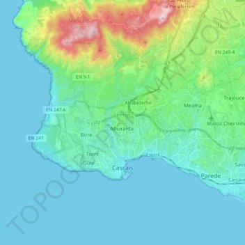
Nom : Carte topographique Cascais, altitude, relief.

Lieu : Cascais, Lisbon, Portugal (38.67589 -9.48655 38.76899 -9.30807)

Altitude moyenne : 97 m

Altitude minimum : 0 m

Altitude maximum : 502 m

The settlement's prosperity led to its administrative independence from Sintra in 1364. On 7 June 1364, the people of Cascais obtained from King Peter I the elevation of the village to the status of town, necessitating the appointment of local judges and administrators. The townspeople were consequently obligated to pay the Crown 200 pounds of gold annually, as well as bearing the expense of paying the local administrators' salaries. Owing to the regions' wealth, these obligations were easily satisfied. The town and the surrounding lands were owned by a succession of feudal lords, the most famous of whom was João das Regras (died 1404), a lawyer and professor of the University of Lisbon who was involved in the ascension of King John I to power as the first King of the House of Aviz.

Autres cartes topographiques

Cliquez sur une carte pour visualiser sa topographie, son altitude et son relief.

Queluz e Belas

Portugal > Lisbon > Queluz e Belas

Queluz e Belas, Sintra, Lisbon, Portugal

Altitude moyenne : 184 m

Lisbon

Portugal > Lisbon

Lisbon, Portugal

Altitude moyenne : 51 m