Géolocaliser

Carte topographique Carrauntoohil

Carte interactive

Cliquez sur la carte pour afficher l’altitude.

À propos de cette carte

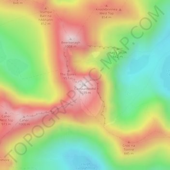
Nom : Carte topographique Carrauntoohil, altitude, relief.

Lieu : Carrauntoohil, Kenmare Municipal District, County Kerry, Munster, V93 A8N1, Ireland (51.99940 -9.74274 51.99950 -9.74264)

Altitude moyenne : 644 m

Altitude minimum : 298 m

Altitude maximum : 1’017 m

Carrauntoohil is the highest mountain in Ireland on all classification scales. It is the 133rd-highest mountain, and 4th most prominent mountain, in Britain and Ireland, on the Simms classification. Carrauntoohil is regarded by the Scottish Mountaineering Club (SMC) as one of 34 Furths, which are defined as mountains above 3,000 feet (910 m) in elevation and meeting the SMC criteria for a Munro (i.e. "sufficient separation"), and which are outside (or furth), of Scotland; this is why Carrauntoohil is also referred to as one of the thirteen Irish Munros.

Wikipedia (CC-BY-SA 3.0)

Autres cartes topographiques

Cliquez sur une carte pour visualiser sa topographie, son altitude et son relief.

Rathmore

Ireland > County Kerry

Rathmore, Rathmore ED, Killarney Municipal District, County Kerry, Munster, P51 PT66, Ireland

Altitude moyenne : 149 m

Murreagh

Ireland > County Kerry

Murreagh, Kenmare Municipal District, County Kerry, Munster, V92 P681, Ireland

Altitude moyenne : 37 m

Dooaghs

Ireland > County Kerry

Dooaghs, Caragh ED, Kenmare Municipal District, County Kerry, Munster, Ireland

Altitude moyenne : 10 m

Castlegregory

Ireland > County Kerry

Castlegregory, Kenmare Municipal District, County Kerry, Munster, V92 F6NX, Ireland

Altitude moyenne : 17 m

Kilgarvan

Ireland > County Kerry

Kilgarvan, Kilgarvan ED, Kenmare Municipal District, County Kerry, Munster, Ireland

Altitude moyenne : 71 m

Ballybunion

Ireland > County Kerry

Ballybunion, County Kerry, Munster, Ireland

Altitude moyenne : 28 m

Dingle

Ireland > County Kerry

Dingle, County Kerry, Munster, Ireland

Altitude moyenne : 41 m

Fossa

Ireland > County Kerry

Fossa, Killarney Rural ED, Killarney Municipal District, County Kerry, Munster, Ireland

Altitude moyenne : 42 m

Beaufort

Ireland > County Kerry

Beaufort, Dunloe ED, Kenmare Municipal District, County Kerry, Munster, Ireland

Altitude moyenne : 38 m

Great Skellig

Ireland > County Kerry

Great Skellig, Kenmare Municipal District, County Kerry, Munster, Ireland

Altitude moyenne : 1 m

Tralee

Ireland > County Kerry

Tralee, County Kerry, Munster, Ireland

Altitude moyenne : 20 m

Stradbally Mountain

Ireland > County Kerry

Stradbally Mountain, Kenmare Municipal District, County Kerry, Munster, Ireland

Altitude moyenne : 487 m

Grenagh

Ireland > County Kerry

Grenagh, Lahard ED, Killarney Municipal District, County Kerry, Munster, Ireland

Altitude moyenne : 36 m

Killarney

Ireland > County Kerry

Killarney, Killarney Municipal District, County Kerry, Munster, Ireland

Altitude moyenne : 57 m

Kenmare Municipal District

Ireland > County Kerry

Kenmare Municipal District, County Kerry, Munster, Ireland

Altitude moyenne : 98 m

Spunkane

Ireland > County Kerry

Spunkane, Emlagh ED, Kenmare Municipal District, County Kerry, Munster, V23 HP11, Ireland

Altitude moyenne : 22 m

Glencloosagh Bay

Ireland > County Kerry

Glencloosagh Bay, Tarbert ED, Listowel Municipal District, County Kerry, Munster, V31 WD66, Ireland

Altitude moyenne : 12 m

Brandon Mountain

Ireland > County Kerry

Brandon Mountain, Kenmare Municipal District, County Kerry, Munster, Ireland

Altitude moyenne : 572 m

Dingle Peninsula

Ireland > County Kerry

Dingle Peninsula, County Kerry, Munster, Ireland

Altitude moyenne : 75 m

Knockanure

Ireland > County Kerry

Knockanure, Listowel Municipal District, County Kerry, Munster, Ireland

Altitude moyenne : 70 m

Kenmare

Ireland > County Kerry > Kenmare

Kenmare, Kenmare Municipal District, County Kerry, Munster, V93 KDX0, Ireland

Altitude moyenne : 87 m

Kilmorna

Ireland > County Kerry

Kilmorna, Kilmeany ED, Listowel Municipal District, County Kerry, Munster, Ireland

Altitude moyenne : 65 m

Kilkeaveragh

Ireland > County Kerry

Kilkeaveragh, Portmagee ED, Kenmare Municipal District, County Kerry, Munster, Ireland

Altitude moyenne : 38 m

Killorglin

Ireland > County Kerry > Killorglin

Killorglin, Kenmare Municipal District, County Kerry, Munster, V93 YD9D, Ireland

Altitude moyenne : 24 m

Brick

Ireland > County Kerry

Brick, Drommartin ED, Listowel Municipal District, County Kerry, Munster, Ireland

Altitude moyenne : 4 m

Ardbeg

Ireland > County Kerry

Ardbeg, Stradbally ED, Kenmare Municipal District, County Kerry, Munster, Ireland

Altitude moyenne : 33 m

Finuge

Ireland > County Kerry

Finuge, Ennismore ED, Listowel Municipal District, County Kerry, Munster, Ireland

Altitude moyenne : 8 m

Rahoneen

Ireland > County Kerry

Rahoneen, Banna ED, Tralee Municipal District, County Kerry, Munster, Ireland

Altitude moyenne : 9 m

Scartaglin

Ireland > County Kerry > Scartaglin

Scartaglin, Tralee Municipal District, County Kerry, Munster, Ireland

Altitude moyenne : 135 m

Rathmore

Ireland > County Kerry > Rathmore

Rathmore, Killarney Municipal District, County Kerry, Munster, Ireland

Altitude moyenne : 154 m

Duagh

Ireland > County Kerry

Duagh, Duagh ED, Listowel Municipal District, County Kerry, Munster, Ireland

Altitude moyenne : 84 m

Dromclogh

Ireland > County Kerry

Dromclogh, Ennismore ED, Listowel Municipal District, County Kerry, Munster, Ireland

Altitude moyenne : 41 m

Ballyduff

Ireland > County Kerry > Ballyduff

Ballyduff, Listowel Municipal District, County Kerry, Munster, Ireland

Altitude moyenne : 29 m

Killarney

Ireland > County Kerry > Killarney

Killarney, Killarney Municipal District, County Kerry, Munster, V93 AYP9, Ireland

Altitude moyenne : 66 m

Tralee Municipal District

Ireland > County Kerry

Tralee Municipal District, County Kerry, Munster, Ireland

Altitude moyenne : 111 m

Dingle

Ireland > County Kerry

Dingle, Kenmare Municipal District, County Kerry, Munster, Ireland

Altitude moyenne : 121 m

Mangerton

Ireland > County Kerry

Mangerton, Kenmare Municipal District, County Kerry, Munster, V93 T250, Ireland

Altitude moyenne : 657 m