Géolocaliser

Carte topographique County Cork

Cliquez sur la carte pour afficher l’altitude.

County Cork

County Cork is located in the province of Munster, bordering Kerry to the west, Limerick to the north, Tipperary to the north-east and Waterford to the east. The county shares separate mountainous borders with Tipperary and Kerry. The terrain on the Kerry border was formed between 360 and 374 million years ago, as part of the rising of the MacGillycuddy's Reeks and Caha Mountains mountains ranges. This occurred during the Devonian period when Ireland was part of a larger continental landmass and located south of the equator. The region's topography of peaks and valleys are characterised by steep ridges formed during the Hercynian period of folding and mountain formation some 300 million years ago.

Wikipedia (CC-BY-SA 3.0)

À propos de cette carte
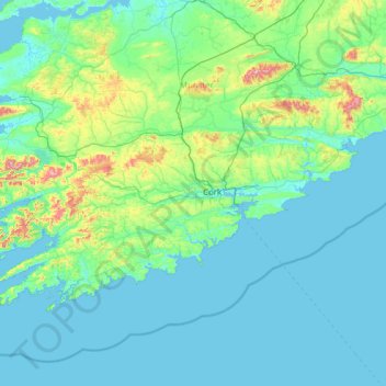
Nom : Carte topographique County Cork, altitude, relief.

Lieu : County Cork, Munster, Ireland (51.38887 -10.30252 52.38779 -7.84115)

Altitude moyenne : 78 m

Altitude minimum : -1 m

Altitude maximum : 989 m

Autres cartes topographiques

Cliquez sur une carte pour visualiser sa topographie, son altitude et son relief.

Cork

Ireland > County Cork > Cork

Altitude moyenne : 94 m

Galway City

Ireland > Galway City

Altitude moyenne : 26 m

Maghera Strand

Ireland

Altitude moyenne : 37 m

Malin Head

Ireland > County Donegal

Altitude moyenne : 4 m

Cromane

Ireland

Altitude moyenne : 3 m

Seefin

Ireland > County Waterford

Altitude moyenne : 498 m

Spike Island

Ireland > County Cork

Altitude moyenne : 2 m

Galtymore

Ireland > County Limerick > The Municipal District of Cappamore — Kilmallock

Galtymore or Galteemore (Irish: Cnoc Mór na nGaibhlte, meaning 'big hill of the Galtees') is a mountain in the province of Munster, Ireland. At 917.9 metres (3,011 ft 6 in), it is one of Ireland's highest mountains, being the 12th-highest on the Arderin list, and 14th-highest on the Vandeleur-Lynam list.…

Altitude moyenne : 594 m

Bartlemy

Ireland > County Cork

Altitude moyenne : 98 m

Bohermeen

Ireland > County Meath

Altitude moyenne : 74 m

Mount Brandon

Ireland > County Kerry

Altitude moyenne : 572 m

Letterkenny

Ireland > County Donegal > Letterkenny

Altitude moyenne : 93 m

River Shannon

Ireland

Altitude moyenne : 39 m

Blackrock

Ireland > County Louth

Altitude moyenne : 5 m

Lough Nagreany

Ireland > County Donegal > Letterkenny

Altitude moyenne : 36 m

Cornaseer

Ireland > County Cavan

Altitude moyenne : 113 m

Knockavilla

Ireland > County Cork

Altitude moyenne : 85 m

Moneystown

Ireland > County Wicklow

Altitude moyenne : 223 m

Ballybrown

Ireland > County Limerick > Limerick

Altitude moyenne : 9 m

Geevagh

Ireland > County Sligo

Altitude moyenne : 92 m

Annayalla

Ireland > County Monaghan

Altitude moyenne : 123 m

Doolin Cave

Ireland > County Clare

Altitude moyenne : 87 m

Inis Meáin

Ireland > County Donegal

Altitude moyenne : 1 m

Mizen Head

Ireland > County Cork

Altitude moyenne : 25 m

Boyne

Ireland > County Meath

Altitude moyenne : 29 m

Mangerton

Ireland > County Kerry

Mangerton Mountain's height and topographic prominence, qualifies it to meet the British Isles Marilyn classification, as well as the Arderin, Simm and Hewitt classifications. Mangerton Mountain ranks as the 10th-highest mountain in Ireland on the MountainViews Online Database, 100 Highest Irish Mountains,…

Altitude moyenne : 657 m

Killiney Hill

Ireland > County Dublin > Killiney

Altitude moyenne : 40 m

Nohoval

Ireland > County Cork

Altitude moyenne : 56 m

Sneem

Ireland > County Kerry > Scrahanagaur

Altitude moyenne : 27 m

Poolbeg Lighthouse

Ireland > County Dublin > Dublin

Altitude moyenne : 0 m

Ardclough

Ireland > County Kildare

Altitude moyenne : 76 m

Ballinagh

Ireland > County Cavan > Bellananagh

Altitude moyenne : 94 m

Blacklion

Ireland > County Cavan

Altitude moyenne : 92 m

Knockmore

Ireland > County Mayo

Altitude moyenne : 108 m

Knockaderry

Ireland > County Waterford > Coolnasmear

Altitude moyenne : 147 m

Beaumont Park

Ireland > County Cork > Cork

Altitude moyenne : 12 m

Stonyford

Ireland > County Kilkenny

Altitude moyenne : 64 m

Ward Cross

Ireland > County Dublin

Altitude moyenne : 75 m

Clare

Ireland > County Galway

Altitude moyenne : 30 m

Hugginstown

Ireland > County Kilkenny

Altitude moyenne : 129 m

Watergrasshill

Ireland > County Cork

According to A Topographical Dictionary of Ireland, published by Samuel Lewis in 1837, Watergrasshill then had a population of 533 people.

Altitude moyenne : 164 m

Cashlaundrumlahan

Ireland > County Galway

Altitude moyenne : 310 m

Bettystown

Ireland > County Meath

Altitude moyenne : 6 m

Beenkeragh

Ireland > County Kerry

Beenkeragh is the second-highest peak in Ireland, on both the Arderin and Vandeleur-Lynam lists. It is the 179th-highest mountain in Britain and Ireland on the Simm classification. Beenkeragh is regarded by the Scottish Mountaineering Club ("SMC") as one of 34 Furths, which is a mountain above 3,000 ft (914 m)…

Altitude moyenne : 654 m

Caher

Ireland > County Kerry

Caher is the 200th–highest mountain in Britain and Ireland on the Simm classification. Caher is regarded by the Scottish Mountaineering Club ("SMC") as one of 34 Furths, which is a mountain above 3,000 ft (914.4 m) in elevation, and meets the other SMC criteria for a Munro (e.g. "sufficient separation"), but…

Altitude moyenne : 617 m

Knocknapeasta

Ireland > County Kerry

It is the 231st-highest mountain in Britain and Ireland on the Simm classification. Cnoc na Péiste is regarded by the Scottish Mountaineering Club ("SMC") as one of 34 Furths, which is a mountain above 3,000 ft (914.4 m) in elevation, and meets the other SMC criteria for a Munro (e.g. "sufficient…

Altitude moyenne : 579 m

Lugnaquilla

Ireland > County Wicklow

Lugnaquilla is the 432nd-highest and 21st most prominent mountain in Britain and Ireland, on the Simms classification. It is regarded by the Scottish Mountaineering Club (SMC) as one of 34 Furths, which is a mountain above 3,000 ft (914 m) in elevation, and meets the other SMC criteria for a Munro (e.g.…

Altitude moyenne : 696 m

Baurtregaum

Ireland > County Kerry

Altitude moyenne : 606 m

Caherconree

Ireland > County Kerry

Altitude moyenne : 536 m

Mweelrea

Ireland > County Mayo

Altitude moyenne : 422 m

Errigal

Ireland > County Donegal

Altitude moyenne : 295 m

Slieve League

Ireland > County Donegal

Altitude moyenne : 233 m

Devil's Bit Mountain

Ireland > County Tipperary

Altitude moyenne : 291 m

Slieve Foye

Ireland > County Louth

Altitude moyenne : 287 m

Blackstairs Mountain

Ireland > County Carlow

Altitude moyenne : 429 m

River Lee (North Channel)

Ireland > County Cork > Cork

Altitude moyenne : 49 m

Clare

Ireland > County Galway

Altitude moyenne : 34 m

Feale

Ireland > County Kerry

Altitude moyenne : 47 m

Derg

Ireland > County Donegal

Altitude moyenne : 166 m

Garavogue

Ireland > County Sligo

Altitude moyenne : 20 m

Camlin

Ireland > County Longford > Cloonfin

Altitude moyenne : 66 m

Doo Lough

Ireland > County Kerry

Altitude moyenne : 20 m

Lough Dan

Ireland > County Wicklow

Altitude moyenne : 309 m

Lough Tay

Ireland > County Wicklow

Altitude moyenne : 395 m

Tory Island

Ireland > County Donegal

Altitude moyenne : 3 m

Lettermore

Ireland > County Cavan

Altitude moyenne : 90 m

Lambay Island

Ireland > County Dublin

Lambay Island is the largest island off the east coast of Ireland. It covers about 2.5 km2 (0.97 sq mi). The highest point – a hill known as Knockbane – rises to 126 m (413 ft). The island's high ground lies to the east and aside from Knockbane includes Heath Hill and Tinian Hill, and in the extreme…

Altitude moyenne : 14 m

Great Skellig

Ireland > County Kerry

The island is of special interest to archaeologists, as the monastic settlement is in unusually good condition. The monastery on the northern peak is situated at an elevation of 170 to 180 m (550 to 600 ft), Christ's Saddle at 129 m (422 ft), and the flagstaff area are 37 m (120 ft) above sea level. The…

Altitude moyenne : 1 m

Little Skellig

Ireland > County Kerry

Altitude moyenne : 0 m

Inishshark

Ireland > County Galway

Altitude moyenne : 11 m

Inishbiggle

Ireland > County Mayo

Altitude moyenne : 3 m

Doneraile Wildlife Park

Ireland > County Cork

Altitude moyenne : 87 m

St Anne's Park

Ireland > County Dublin > Dublin

Altitude moyenne : 13 m

Rathfarnham

Ireland > County Dublin

Altitude moyenne : 56 m

Benbulbin

Ireland > County Sligo

Altitude moyenne : 257 m

Bealad Cross Roads

Ireland > County Cork

Altitude moyenne : 94 m

Timahoe

Ireland > County Laois

Altitude moyenne : 146 m

Kilpedder

Ireland > County Wicklow

Altitude moyenne : 99 m

Brandon Hill

Ireland > County Kilkenny

Brandon Hill (Irish: Cnoc Bhréanail) is the highest mountain in County Kilkenny, Ireland, with an elevation of 515 m (1,690 ft) and prominence at 448 m (1,470 ft). The South Leinster Way, a long-distance trail, meandering through the Barrow Valley and traverses Brandon Hill. The village of Graiguenamanagh and…

Altitude moyenne : 294 m

Annacarty

Ireland > County Tipperary

Altitude moyenne : 130 m

Ballinahown

Ireland > County Westmeath

Altitude moyenne : 49 m

Ticknevin

Ireland > County Kildare

Altitude moyenne : 80 m

Grangemockler

Ireland > County Tipperary

Altitude moyenne : 165 m

Magheracloone

Ireland > County Monaghan

Altitude moyenne : 57 m

Glengarriff

Ireland > County Cork

Altitude moyenne : 66 m

Knockanore

Ireland > County Kerry

Altitude moyenne : 155 m

Galway Bay

Ireland

Altitude moyenne : 0 m

Dollymount

Ireland

Altitude moyenne : 6 m

Ardnacrusha

Ireland > County Clare

Altitude moyenne : 39 m

Ardrahan

Ireland > County Galway

Altitude moyenne : 32 m

Hill of Tara

Ireland > County Meath

Altitude moyenne : 106 m

Équipez-vous pour votre prochaine aventure :

🛌Sac de couchage thermique - Conçu pour résister aux nuits fraîches des sommets helvétiques
🗻Crampons de randonnée - Adhérence sur neige et glace
🚲Mini pompe à vélo - Compacte et puissante pour regonfler vos pneus rapidement
🩹Pansements spécial ampoules - Continuez votre marche malgré les frottements
🗺️Cartes de randonnée - Le support papier indispensable en complément du numérique

En tant que Partenaire Amazon, ce site perçoit une commission sur les achats éligibles sans surcoût pour vous.