
Faire un don
Équipez-vous pour votre prochaine aventure :
En tant que Partenaire Amazon, ce site perçoit une commission sur les achats éligibles sans surcoût pour vous.
Carte topographique Tikal
Cliquez sur la carte pour afficher l’altitude.
Faire un don
Équipez-vous pour votre prochaine aventure :
En tant que Partenaire Amazon, ce site perçoit une commission sur les achats éligibles sans surcoût pour vous.
Tikal
La ville a été complètement cartographiée et on sait qu’elle couvrait une superficie de plus de 16 km2 et rassemblait environ 3 000 structures,. Sur le plan topographique, le site est composé d'une série de crêtes calcaires parallèles s'élevant au-dessus des basses terres marécageuses. Les principaux monuments du site sont regroupés sur les zones de terrain les plus élevées et reliées par des chaussées surélevées franchissant des marais. La zone entourant Tikal constitue le parc national de Tikal et la zone protégée couvre 570 km².
Faire un don
Équipez-vous pour votre prochaine aventure :
En tant que Partenaire Amazon, ce site perçoit une commission sur les achats éligibles sans surcoût pour vous.
À propos de cette carte
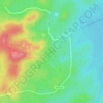
Nom : Carte topographique Tikal, altitude, relief.
Lieu : Tikal, Mahler Causeway, Flores, Petén, Guatemala (17.20940 -89.63277 17.23224 -89.61175)
Altitude moyenne : 261 m
Altitude minimum : 224 m
Altitude maximum : 318 m
Faire un don
Équipez-vous pour votre prochaine aventure :
En tant que Partenaire Amazon, ce site perçoit une commission sur les achats éligibles sans surcoût pour vous.