Géolocaliser

Carte topographique Dingle

Carte interactive

Cliquez sur la carte pour afficher l’altitude.

À propos de cette carte
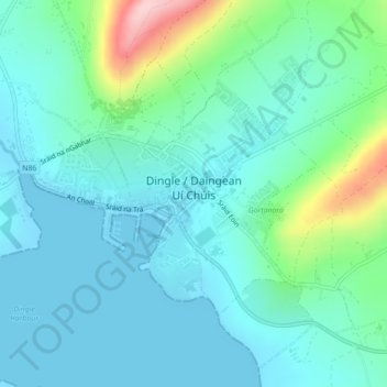
Nom : Carte topographique Dingle, altitude, relief.

Lieu : Dingle, County Kerry, Munster, Ireland (52.13074 -10.29854 52.15002 -10.25466)

Altitude moyenne : 41 m

Altitude minimum : -1 m

Altitude maximum : 206 m

Dingle's St. Mary's is a neo-Gothic church built to designs by J. J. McCarthy and O'Connell. The foundation stone was laid in 1862. It originally had a nave and aisles separated by arcades, supported on columns capped by octagonal tops. The arcades were demolished in one of the most radical reordering schemes to have been executed in Ireland. The project also saw the demolition of the exterior walls to below the original clerestory level, and, most notably, of the attic and upper ranges of the west elevation.

Wikipedia (CC-BY-SA 3.0)

Autres cartes topographiques

Cliquez sur une carte pour visualiser sa topographie, son altitude et son relief.

Ballyseedy Wood

Ireland > County Kerry

Ballyseedy Wood, Ballyseedy ED, Tralee Municipal District, County Kerry, Munster, Ireland

Altitude moyenne : 20 m

Shronowen

Ireland > County Kerry

Shronowen, Shronowen ED, Listowel Municipal District, County Kerry, Munster, Ireland

Altitude moyenne : 27 m

Tralee

Ireland > County Kerry

Tralee, County Kerry, Munster, Ireland

Altitude moyenne : 22 m

Torc Mountain

Ireland > County Kerry

Torc Mountain, Killarney Municipal District, County Kerry, Munster, V93 RR59, Ireland

Altitude moyenne : 202 m

Lisselton

Ireland > County Kerry

Lisselton, Listowel Municipal District, County Kerry, Munster, Ireland

Altitude moyenne : 34 m

Farranfore

Ireland > County Kerry

Farranfore, Tralee Municipal District, County Kerry, Munster, V93 YP44, Ireland

Altitude moyenne : 59 m

Stradbally Mountain

Ireland > County Kerry

Stradbally Mountain, Kenmare Municipal District, County Kerry, Munster, Ireland

Altitude moyenne : 487 m

Glencar

Ireland > County Kerry

Glencar, Kenmare Municipal District, County Kerry, Munster, Ireland

Altitude moyenne : 114 m

Cahersiveen

Ireland > County Kerry

Cahersiveen, County Kerry, Munster, V23 FF95, Ireland

Altitude moyenne : 66 m

Kilgarvan

Ireland > County Kerry

Kilgarvan, Kilgarvan ED, Kenmare Municipal District, County Kerry, Munster, Ireland

Altitude moyenne : 71 m

Brosna

Ireland > County Kerry

Brosna, Tralee Municipal District, County Kerry, Munster, Ireland

Altitude moyenne : 163 m

Killarney

Ireland > County Kerry

Killarney, Killarney Municipal District, County Kerry, Munster, Ireland

Altitude moyenne : 57 m

Rathmore

Ireland > County Kerry

Rathmore, Rathmore ED, Killarney Municipal District, County Kerry, Munster, P51 PT66, Ireland

Altitude moyenne : 149 m

Lispole

Ireland > County Kerry

Lispole, Kenmare Municipal District, County Kerry, Munster, V92 DN23, Ireland

Altitude moyenne : 107 m

Kilcummin

Ireland > County Kerry

Kilcummin, Kilcummin ED, Killarney Municipal District, County Kerry, Munster, Ireland

Altitude moyenne : 142 m

Cromane Upper

Ireland > County Kerry

Cromane Upper, Killorglin ED, Kenmare Municipal District, County Kerry, Munster, Ireland

Altitude moyenne : 18 m

Killorglin

Ireland > County Kerry

Killorglin, Killorglin ED, Kenmare Municipal District, County Kerry, Munster, Ireland

Altitude moyenne : 23 m

Lyreboy

Ireland > County Kerry

Lyreboy, Maum ED, Kenmare Municipal District, County Kerry, Munster, Ireland

Altitude moyenne : 342 m

Killarney

Ireland > County Kerry

Killarney, Killarney Urban ED, Killarney Municipal District, County Kerry, Munster, Ireland

Altitude moyenne : 39 m

Glenmore

Ireland > County Kerry

Glenmore, Glanmore ED, Kenmare Municipal District, County Kerry, Munster, Ireland

Altitude moyenne : 269 m

Glanmore

Ireland > County Kerry

Glanmore, Kilgobban ED, Kenmare Municipal District, County Kerry, Munster, Ireland

Altitude moyenne : 187 m

Tralee

Ireland > County Kerry

Tralee, County Kerry, Munster, Ireland

Altitude moyenne : 20 m

Beheenagh

Ireland > County Kerry

Beheenagh, Kilgobban ED, Kenmare Municipal District, County Kerry, Munster, Ireland

Altitude moyenne : 347 m

Banna Strand

Ireland > County Kerry

Banna Strand, Banna ED, Tralee Municipal District, County Kerry, Munster, Ireland

Altitude moyenne : 4 m

Lauragh

Ireland > County Kerry

Lauragh, Kenmare Municipal District, County Kerry, Munster, Ireland

Altitude moyenne : 89 m

Killarney

Ireland > County Kerry > Killarney

Killarney, Killarney Municipal District, County Kerry, Munster, V93 AYP9, Ireland

Altitude moyenne : 66 m

Glashanacree

Ireland > County Kerry

Glashanacree, Kilshenane ED, Tralee Municipal District, County Kerry, Munster, Ireland

Altitude moyenne : 143 m

Derrybanane

Ireland > County Kerry

Derrybanane, Flesk ED, Killarney Municipal District, County Kerry, Munster, Ireland

Altitude moyenne : 299 m

Valencia Island

Ireland > County Kerry

Valencia Island, Kenmare Municipal District, County Kerry, Munster, Ireland

Altitude moyenne : 39 m

Barrow

Ireland > County Kerry

Barrow, Ballynahaglish ED, Tralee Municipal District, County Kerry, Munster, Ireland

Altitude moyenne : 7 m

Lough Guitane

Ireland > County Kerry

Lough Guitane, Flesk ED, Killarney Municipal District, County Kerry, Munster, Ireland

Altitude moyenne : 112 m

Aghadoe

Ireland > County Kerry

Aghadoe, County Kerry, Munster, Ireland

Altitude moyenne : 132 m

Knoppoge

Ireland > County Kerry

Knoppoge, Ballyduff ED, Listowel Municipal District, County Kerry, Munster, Ireland

Altitude moyenne : 29 m

Gunsborough

Ireland > County Kerry

Gunsborough, Gunsborough ED, Listowel Municipal District, County Kerry, Munster, V31 TR74, Ireland

Altitude moyenne : 54 m

Barraduff

Ireland > County Kerry > Barraduff

Barraduff, Killarney Municipal District, County Kerry, Munster, Ireland

Altitude moyenne : 124 m

Knocknacree

Ireland > County Kerry

Knocknacree, Ballyduff ED, Listowel Municipal District, County Kerry, Munster, Ireland

Altitude moyenne : 51 m

Pallis

Ireland > County Kerry

Pallis, Lahard ED, Killarney Municipal District, County Kerry, Munster, Ireland

Altitude moyenne : 48 m

Rattoo Round Tower

Ireland > County Kerry

Rattoo Round Tower, R551, Ballyduff ED, Listowel Municipal District, County Kerry, Munster, Ireland

Altitude moyenne : 16 m

Ballincolla

Ireland > County Kerry

Ballincolla, Dunurlin ED, Kenmare Municipal District, County Kerry, Munster, Ireland

Altitude moyenne : 22 m

Knockbrack

Ireland > County Kerry

Knockbrack, Ballynorig ED, Listowel Municipal District, County Kerry, Munster, Ireland

Altitude moyenne : 20 m

Heirhill

Ireland > County Kerry

Heirhill, Ballyheige ED, Listowel Municipal District, County Kerry, Munster, Ireland

Altitude moyenne : 54 m

Raheens

Ireland > County Kerry

Raheens, Bahaghs ED, Kenmare Municipal District, County Kerry, Munster, Ireland

Altitude moyenne : 166 m

Ballintobernig

Ireland > County Kerry

Ballintobernig, Ratass ED, Tralee Municipal District, County Kerry, Munster, Ireland

Altitude moyenne : 182 m

Castlelough

Ireland > County Kerry

Castlelough, Muckross ED, Killarney Municipal District, County Kerry, Munster, V93 RR59, Ireland

Altitude moyenne : 35 m

Ballydunlea

Ireland > County Kerry

Ballydunlea, Tralee Rural ED, Tralee Municipal District, County Kerry, Munster, Ireland

Altitude moyenne : 158 m

Drombeg

Ireland > County Kerry

Drombeg, Shronowen ED, Listowel Municipal District, County Kerry, Munster, Ireland

Altitude moyenne : 43 m

Knockglass Beg

Ireland > County Kerry

Knockglass Beg, Knockglass ED, Kenmare Municipal District, County Kerry, Munster, Ireland

Altitude moyenne : 94 m

Ballyconnell

Ireland > County Kerry

Ballyconnell, Kilfeighny ED, Listowel Municipal District, County Kerry, Munster, Ireland

Altitude moyenne : 41 m

Coolroe Upper

Ireland > County Kerry

Coolroe Upper, Glanbehy ED, Kenmare Municipal District, County Kerry, Munster, Ireland

Altitude moyenne : 178 m

Cahernageeha

Ireland > County Kerry

Cahernageeha, Darrynane ED, Kenmare Municipal District, County Kerry, Munster, Ireland

Altitude moyenne : 223 m