
Carte topographique Madagascar
Carte interactive
Cliquez sur la carte pour afficher l’altitude.
Madagascar
L’île de Madagascar s’est séparée du continent africain il y a environ 120 millions d'années, en raison de la dérive des continents. Elle peut être divisée en cinq régions géographiques : la côte est, le massif Tsaratanana, les hauts plateaux du centre, la côte ouest et le sud-ouest. Les altitudes maximales longent la côte est.
À propos de cette carte
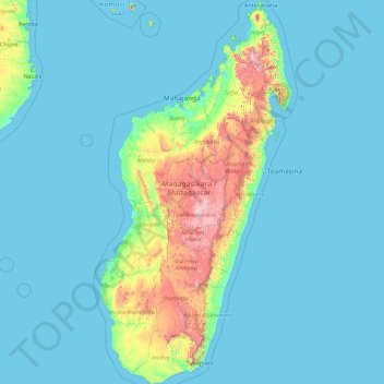
Nom : Carte topographique Madagascar, altitude, relief.
Lieu : Madagascar, Province d’Antananarivo, Madagascar (-25.60614 43.22023 -11.95203 50.48606)
Altitude moyenne : 144 m
Altitude minimum : -1 m
Altitude maximum : 2’699 m