
Carte topographique Kangchenjunga
Cliquez sur la carte pour afficher l’altitude.
Kangchenjunga
Le Kangchenjunga (appelé aussi Kanchenjunga, Kangchen Dzö-nga, Kachendzonga, Kintchindjinga ou Kangchanfanga) est un sommet de l'Himalaya, sur la frontière indo-népalaise, à l'est du Népal, entre le district de Taplejung et l'État indien du Sikkim où il peut être vu notamment de la capitale Gangtok. Son altitude de 8 586 mètres le classe troisième sommet le plus haut sur Terre, après l'Everest et le K2, et fait du Kangchenjunga le point culminant de l'Inde. Jusqu'en 1852, il fut considéré comme le plus haut sommet du monde.
À propos de cette carte
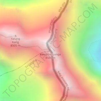
Nom : Carte topographique Kangchenjunga, altitude, relief.
Lieu : Kangchenjunga, Chungthang, Mangan, Sikkim, Inde (27.70296 88.14743 27.70306 88.14753)
Altitude moyenne : 7’725 m
Altitude minimum : 6’553 m
Altitude maximum : 8’587 m