Carte topographique Cork
Carte interactive
Cliquez sur la carte pour afficher l’altitude.
À propos de cette carte
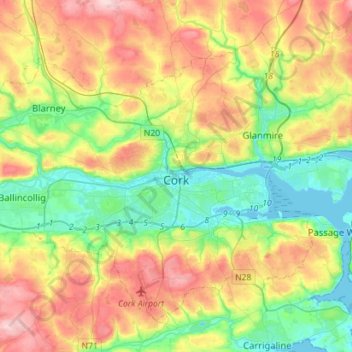
Nom : Carte topographique Cork, altitude, relief.
Lieu : Cork, County Cork, Munster, Ireland (51.82731 -8.63785 51.97014 -8.35513)
Altitude moyenne : 79 m
Altitude minimum : -3 m
Altitude maximum : 197 m
The climate of Cork, like the majority of Ireland, is mild oceanic (Cfb in the Köppen climate classification) and changeable with abundant rainfall and a lack of temperature extremes. Cork lies in plant Hardiness zone 9b. Met Éireann maintains a climatological weather station at Cork Airport, a few kilometres south of the city centre. The airport is at an altitude of 151 metres (495 ft) and temperatures can often differ by a few degrees between the airport and the rest of the city. There are also smaller synoptic weather stations at UCC and Clover Hill. Due to its position on the coast, Cork city is subject to occasional flooding.
Autres cartes topographiques
Cliquez sur une carte pour visualiser sa topographie, son altitude et son relief.
Cork
Ireland > County Cork > Cork
Cork, County Cork, Munster, T12 T997, Ireland
Altitude moyenne : 94 m
Kilgobbin
Kilgobbin, Ballinadee ED, The Municipal District of Bandon-Kinsale, County Cork, Munster, Ireland
Altitude moyenne : 85 m
Ballincollig
Ireland > County Cork > Cork
Ballincollig, Cork, County Cork, Munster, P31 TW88, Ireland
Altitude moyenne : 62 m
Inchigeelagh
Inchigeelagh, Municipal District of Macroom, County Cork, Munster, P12 W864, Ireland
Altitude moyenne : 135 m
Knockawaddra
Knockawaddra, Ballingurteen ED, West Cork, County Cork, Munster, Ireland
Altitude moyenne : 154 m
Killeagh
Killeagh, The Municipal District of East Cork, County Cork, Munster, P36 KN61, Ireland
Altitude moyenne : 32 m
Gortroe
Gortroe, The Municipal District of Fermoy, County Cork, Munster, P61 TD96, Ireland
Altitude moyenne : 120 m
Lyre
Lyre, Tincoora, The Municipal District of Kanturk-Mallow, County Cork, Munster, Ireland
Altitude moyenne : 214 m
Coolmore Cross
Coolmore Cross, Carrigaline ED, Municipal District of Carrigaline, County Cork, Munster, P43 DA03, Ireland
Altitude moyenne : 21 m
Water-rock
Water-rock, Carrigtohill ED, Municipal District of Cobh, County Cork, Munster, Ireland
Altitude moyenne : 22 m
Castletownroche
Castletownroche, The Municipal District of Fermoy, County Cork, Munster, P51 K064, Ireland
Altitude moyenne : 67 m
Dundareirke
Dundareirke, Kilnamartery, Municipal District of Macroom, County Cork, Munster, Ireland
Altitude moyenne : 116 m
Ballincollig Regional Park
Ireland > County Cork > Cork
Ballincollig Regional Park, West Village, Carrigrohane Beg ED, Cork, County Cork, Munster, Ireland
Altitude moyenne : 55 m
Castlemartyr
Castlemartyr, The Municipal District of East Cork, County Cork, Munster, Ireland
Altitude moyenne : 14 m
Berrings
Berrings, Dripsey, Municipal District of Macroom, County Cork, Munster, Ireland
Altitude moyenne : 113 m
Moneyreague
Moneyreague, Coolmountain ED, West Cork, County Cork, Munster, Ireland
Altitude moyenne : 122 m
Waterfall
Waterfall, Inishkenny, Municipal District of Carrigaline, County Cork, Munster, T12 CYF2, Ireland
Altitude moyenne : 96 m
Macroom
Macroom, Municipal District of Macroom, County Cork, Munster, Ireland
Altitude moyenne : 110 m
Ballymore
Ballymore, Cobh Rural ED, Municipal District of Cobh, County Cork, Munster, Ireland
Altitude moyenne : 40 m
Aghabullogue
Aghabullogue, Municipal District of Macroom, County Cork, Munster, P12 DY92, Ireland
Altitude moyenne : 133 m
Liscahane Beg
Liscahane Beg, Kinsale Rural, The Municipal District of Bandon-Kinsale, County Cork, Munster, Ireland
Altitude moyenne : 47 m
Kilmurry
Kilmurry, Municipal District of Macroom, County Cork, Munster, P14 R940, Ireland
Altitude moyenne : 122 m
Mallow
Mallow, The Municipal District of Kanturk-Mallow, County Cork, Munster, Ireland
Altitude moyenne : 77 m
Baltimore
Baltimore, West Cork, County Cork, Munster, P81 F623, Ireland
Altitude moyenne : 23 m
Kilmacsimon
Kilmacsimon, Knockroe, The Municipal District of Bandon-Kinsale, County Cork, Munster, Ireland
Altitude moyenne : 50 m
Timoleague
Timoleague, The Municipal District of Bandon-Kinsale, County Cork, Munster, P72 DX23, Ireland
Altitude moyenne : 48 m
Dromsarane
Dromsarane, Castlemartyr ED, The Municipal District of East Cork, County Cork, Munster, Ireland
Altitude moyenne : 54 m
Glounthaune
Glounthaune, Municipal District of Cobh, County Cork, Munster, T45 V201, Ireland
Altitude moyenne : 52 m
Tawnies Lower
Tawnies Lower, Clonakilty Urban ED, West Cork, County Cork, Munster, Ireland
Altitude moyenne : 46 m
Ladysbridge
Ladysbridge, Ightermurragh, The Municipal District of East Cork, County Cork, Munster, P25 X820, Ireland
Altitude moyenne : 30 m
Ringcurran
Ringcurran, The Municipal District of Bandon-Kinsale, County Cork, Munster, Ireland
Altitude moyenne : 60 m
Ardamadane
Ireland > County Cork > Cork
Ardamadane, Blarney ED, Cork, County Cork, Munster, Ireland
Altitude moyenne : 92 m
Doneraile
Doneraile, The Municipal District of Fermoy, County Cork, Munster, Ireland
Altitude moyenne : 85 m
Kilmaclenine
Kilmaclenine, The Municipal District of Kanturk-Mallow, County Cork, Munster, Ireland
Altitude moyenne : 109 m
Dunbulloge
Dunbulloge, Killeagh, Municipal District of Cobh, County Cork, Munster, Ireland
Altitude moyenne : 117 m
Ringrone
Ringrone, Kinsale Rural, The Municipal District of Bandon-Kinsale, County Cork, Munster, Ireland
Altitude moyenne : 41 m
Monkstown
Ireland > County Cork > Municipal District of Carrigaline
Monkstown, Municipal District of Carrigaline, County Cork, Munster, T12 KT5N, Ireland
Altitude moyenne : 44 m
Aghada
Aghada, Corkbeg ED, The Municipal District of East Cork, County Cork, Munster, P25 HX04, Ireland
Altitude moyenne : 25 m
Halfway
Halfway, Dunderrow, Municipal District of Carrigaline, County Cork, Munster, T12 KT99, Ireland
Altitude moyenne : 96 m
Cloghmacow
Cloghmacow, Warrenscourt, Municipal District of Macroom, County Cork, Munster, Ireland
Altitude moyenne : 118 m
Roughgrove East
Roughgrove East, Kilbrogan, The Municipal District of Bandon-Kinsale, County Cork, Munster, Ireland
Altitude moyenne : 105 m
Banteer
Banteer, The Municipal District of Kanturk-Mallow, County Cork, Munster, Ireland
Altitude moyenne : 85 m
Lissanly
Lissanly, Cloyne ED, The Municipal District of East Cork, County Cork, Munster, Ireland
Altitude moyenne : 34 m
Ballygarvan
Ballygarvan, Municipal District of Carrigaline, County Cork, Munster, T12 RR02, Ireland
Altitude moyenne : 70 m
Killumney
Killumney, Ballygroman ED, Municipal District of Macroom, County Cork, Munster, Ireland
Altitude moyenne : 79 m
Coolflugh
Ireland > County Cork > Cork
Coolflugh, Matehy, Cork, County Cork, Munster, T23 YX51, Ireland
Altitude moyenne : 71 m
Lyre (Barry)
Lyre (Barry), Gortnaskehy, The Municipal District of Fermoy, County Cork, Munster, Ireland
Altitude moyenne : 192 m
Scartlea Upper
Scartlea Upper, Cloyne ED, The Municipal District of East Cork, County Cork, Munster, Ireland
Altitude moyenne : 54 m