Géolocaliser

Carte topographique Surat

Carte interactive

Cliquez sur la carte pour afficher l’altitude.

À propos de cette carte

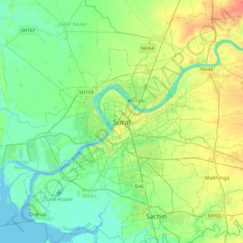
Nom : Carte topographique Surat, altitude, relief.

Lieu : Surat, Katargam Taluka, Surat District, Gujarat, 395008, India (21.04949 72.67171 21.36949 72.99171)

Altitude moyenne : 13 m

Altitude minimum : -3 m

Altitude maximum : 38 m

Surat is a port city situated on the banks of the Tapi river. After dams were built, water flow in Tapi deceased causing the original port facilities to close. The nearest port is now in the Magadalla and Hazira area of Surat Metropolitan Region. It has a famous beach called 'Dumas Beach' located in Dumas.The city is located at 21°12′18″N 72°50′24″E / 21.205°N 72.840°E / 21.205; 72.840. It has an average elevation of 13 metres. The Surat district is surrounded by the Bharuch, Narmada, Navsari and Tapi districts, and Gulf of Cambay to the west. The climate is tropical and monsoon rainfall is abundant. According to the Bureau of Indian Standards, the town falls under seismic zone-III, in a scale of I to V (in order of increasing vulnerability to earthquakes).

Wikipedia (CC-BY-SA 3.0)

Autres cartes topographiques

Cliquez sur une carte pour visualiser sa topographie, son altitude et son relief.

Surat

India > Gujarat > Katargam Taluka > Surat

Surat, Katargam Taluka, Surat, Gujarat, 395001, India

Altitude moyenne : 11 m