
Carte topographique Ballater
Carte interactive
Cliquez sur la carte pour afficher l’altitude.
Ballater
Situé à une altitude de 123 m, Ballater est un centre pour les randonneurs, connu aussi pour ses eaux de source, qui permettraient de guérir les écrouelles. Le château de Balmoral est situé à environ 12 km à l'ouest de la ville, et Birkhall à 3 km au sud-ouest. La population recensée en 2001 est de 1 446 habitants, estimée à 1 520 en 2008.
À propos de cette carte
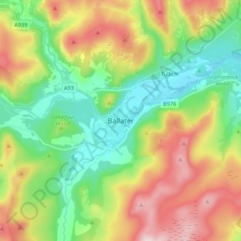
Nom : Carte topographique Ballater, altitude, relief.
Lieu : Ballater, Aberdeenshire, Écosse, AB35 5QD, Royaume-Uni (57.00951 -3.08052 57.08951 -3.00052)
Altitude moyenne : 360 m
Altitude minimum : 184 m
Altitude maximum : 645 m