
Carte topographique གངས་རིན་པོ་ཆེ 冈仁波齐峰
Carte interactive
Cliquez sur la carte pour afficher l’altitude.
གངས་རིན་པོ་ཆེ 冈仁波齐峰
Le mont Kailash (du sanskrit : कैलास पर्वत, IAST : Kailāsa Parvata ; translittération en tibétain kai la sha Wylie : kai la sha), également appelé en tibétain Gang Rinpoché (tibétain : གངས་རིན་པོ་ཆེ, Wylie : gangs rin po che, pinyin tibétain : Kangrinboqê, THL : gang rinpoche ; qui donne la translittération en chinois : 冈仁波齐峰 ; pinyin : gāngrénbōqí fēng ; litt. « sommet de monsieur/rinpoché gang ») et dans le jaïnisme aṣṭapāda (sanskrit : अष्टपाद, aṣṭapāda, huit pieds), est une montagne culminant à 6 638 mètres d'altitude et faisant partie de la chaîne de Gangdise ou Transhimalaya. Elle est située dans la préfecture de Ngari, dans la région autonome du Tibet, à proximité du lac Manasarovar et du lac Rakshastal. Quatre des plus grands fleuves d'Asie, l'Indus, le Sutlej, le Brahmapoutre et la Karnali prennent leur source à proximité du mont Kailash.
À propos de cette carte
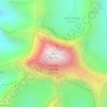
Nom : Carte topographique གངས་རིན་པོ་ཆེ 冈仁波齐峰, altitude, relief.
Altitude moyenne : 5’756 m
Altitude minimum : 5’247 m
Altitude maximum : 6’585 m