Géolocaliser

Carte topographique Western Australia

Cliquez sur la carte pour afficher l’altitude.

Western Australia

Because the only mountain-building since then has been of the Stirling Range with the rifting from Antarctica, the land is extremely eroded and ancient, with no part of the state above 1,245 metres (4,085 ft) AHD (at Mount Meharry in the Hamersley Range of the Pilbara region). Most of the state is a low plateau with an average elevation of about 400 metres (1,200 ft), very low relief, and no surface runoff. This descends relatively sharply to the coastal plains, in some cases forming a sharp escarpment (as with the Darling Range/Darling Scarp near Perth).

Wikipedia (CC-BY-SA 3.0)

À propos de cette carte
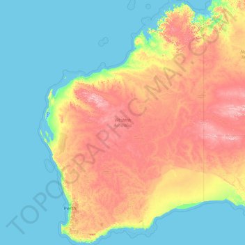
Nom : Carte topographique Western Australia, altitude, relief.

Lieu : Western Australia, Australia (-35.24185 112.86567 -13.50769 129.01997)

Altitude moyenne : 194 m

Altitude minimum : -2 m

Altitude maximum : 1’208 m

Autres cartes topographiques

Cliquez sur une carte pour visualiser sa topographie, son altitude et son relief.

Brisbane

Australia > Queensland > Brisbane

Altitude moyenne : 45 m

Perth

Australia > Western Australia > City of Perth

Perth, the capital of Western Australia, is situated on the Swan Coastal Plain, a flat expanse of sandy soil nestled between the Indian Ocean to the west and the Darling Scarp to the east. The Darling Scarp, also known as the Darling Range, is a low escarpment that extends north–south, marking a distinct…

Altitude moyenne : 26 m

Adelaide

Australia > South Australia > Adelaide

Adelaide is north of the Fleurieu Peninsula, on the Adelaide Plains between the Gulf St Vincent and the low-lying Mount Lofty Ranges. The city stretches 20 km (12 mi) from the coast to the foothills, and 90 km (56 mi) from Gawler at its northern extent to Sellicks Beach in the south. According to the Regional…

Altitude moyenne : 148 m

Canberra

Australia

The area chosen for the capital had been inhabited by Indigenous Australians for up to 21,000 years, with the principal group being the Ngunnawal people. European settlement commenced in the first half of the 19th century, as evidenced by surviving landmarks such as St John's Anglican Church and Blundells…

Altitude moyenne : 638 m

Melbourne

Australia > Victoria

Melbourne is also prone to isolated convective showers forming when a cold pool crosses the state, especially if there is considerable daytime heating. These showers are often heavy and can include hail, squalls, and significant drops in temperature, but they often pass through very quickly with a rapid…

Altitude moyenne : 49 m

Sunshine Coast

Australia > Queensland > Sunshine Coast Regional

The Sunshine Coast in Queensland, Australia, showcases a diverse topography that harmoniously blends coastal plains with rugged hinterlands. Along its eastern edge, the region features expansive sandy beaches and coastal dunes that transition smoothly into fertile lowlands. Inland, the terrain becomes more…

Altitude moyenne : 109 m

Sydney

Australia > New South Wales

Phillip had been given no instructions for urban development, but in July 1788 submitted a plan for the new town at Sydney Cove. It included a wide central avenue, a permanent Government House, law courts, hospital and other public buildings, but no provision for warehouses, shops, or other commercial…

Altitude moyenne : 32 m

Gold Coast

Australia > Queensland > Gold Coast

Altitude moyenne : 42 m

Ballarat

Australia > Victoria

Ballarat has a moderate oceanic climate (Köppen climate classification Cfb) with four distinct seasons. Its elevation, ranging between 400 and 630 metres (1,310 and 2,070 feet) above sea level, causes its mean monthly temperatures to tend to be on average 3 to 5 °C (5 to 9 °F) below those of Melbourne,…

Altitude moyenne : 470 m

Great Dividing Range

Australia

The Great Dividing Range, also known as the East Australian Cordillera or the Eastern Highlands, is a cordillera system in eastern Australia consisting of an expansive collection of mountain ranges, plateaus and rolling hills, that runs roughly parallel to the east coast of Australia and forms the…

Altitude moyenne : 117 m

Mount Kosciuszko

Australia > New South Wales

Mount Kosciuszko is the highest summit in mainland Australia. Until 1977 it was possible to drive from Charlotte Pass to within a few metres of the summit, but in 1977 the road was closed to public motor vehicle access due to environmental concerns. The road is open from Charlotte Pass for walkers and cyclists…

Altitude moyenne : 2’035 m

Geelong

Australia > Victoria

Altitude moyenne : 42 m

Cairns

Australia > Queensland

South of Smithfield and inland from the Northern Beaches along the edge of the Barron River flood plain are the suburbs of Caravonica, Kamerunga, Freshwater, and Stratford. This area is sometimes referred to as Freshwater Valley, though it is actually the lower part of Redlynch Valley; further up the valley…

Altitude moyenne : 176 m

Darwin

Australia > City of Darwin

Altitude moyenne : 8 m

Frankston

Australia > Victoria > Frankston

Olivers Hill is the most prominent elevation in Frankston which rises to 55 metres above sea level (180 feet) at its highest point in the suburb. Its origins date to approximately 415 to 360 million years ago. Its base is Mount Eliza Granite dating from the Devonian period, which was covered in lava tuffs in…

Altitude moyenne : 36 m

Bendigo

Australia > Victoria

Altitude moyenne : 223 m

Toowoomba

Australia > Queensland

The city occupies the edge of the range and the low ridges behind it. Two valleys run north from the southern boundary, each arising from springs either side of Middle Ridge near Spring Street at an altitude of around 680 m. These waterways, East Creek and West Creek, flow together just north of the CBD to…

Altitude moyenne : 458 m

Grafton

Australia > New South Wales

Altitude moyenne : 36 m

Mildura

Australia > Victoria > Mildura

Altitude moyenne : 52 m

Riddells Creek

Australia > Victoria

Altitude moyenne : 450 m

Innisfail

Australia > Queensland

Altitude moyenne : 12 m

Hunter Valley

Australia > New South Wales > Cessnock

Altitude moyenne : 70 m

Mackay

Australia > Queensland

Altitude moyenne : 13 m

Launceston

Australia > Tasmania > Launceston

Launceston is at 41°26′31″S 147°8′42″E / 41.44194°S 147.14500°E / -41.44194; 147.14500 in the Tamar Valley, Northern Tasmania. The valley was formed by volcanic and glacial forces over 10 million years ago. The city is about 45 kilometres (28 mi) south of the Bass Strait, with its closest…

Altitude moyenne : 218 m

Busselton

Australia > Western Australia

Altitude moyenne : 4 m

Inverloch

Australia > Victoria > Inverloch

Altitude moyenne : 20 m

Rockhampton

Australia > Queensland

Altitude moyenne : 48 m

Cessnock

Australia > New South Wales

Altitude moyenne : 142 m

Dubbo

Australia > New South Wales > Dubbo

Altitude moyenne : 307 m

Wollongong

Australia > New South Wales > Wollongong

Altitude moyenne : 115 m

Garden of the Grampians

Australia > Victoria

Altitude moyenne : 581 m

Curtin

Australia > Western Australia

Altitude moyenne : 349 m

Blue Mountains

Australia > New South Wales

A sandstone plateau dominated by a landscape of endless eucalyptus forests, the Blue Mountains are located at the top of a 470-million-year-old quartzite. In the Permian period, a shallow sea covered the region, when rivers brought shales, siltstones and mudstones. Then during the Mesozoic period, rivers…

Altitude moyenne : 566 m

Lithgow

Australia > New South Wales

Altitude moyenne : 986 m

Bathurst

Australia > New South Wales

Altitude moyenne : 760 m

Australian Alps

Australia > New South Wales

The Australian Alps are a mountain range in southeast Australia. It comprises an interim Australian bioregion, and is the highest mountain range in Australia. The range straddles the borders of eastern Victoria, southeastern New South Wales, and the Australian Capital Territory. It contains Australia's only…

Altitude moyenne : 2’037 m

Gladstone

Australia > Queensland

Altitude moyenne : 24 m

Townsville

Australia > Queensland

Altitude moyenne : 30 m

Hervey Bay

Australia > Queensland

Altitude moyenne : 6 m

Macleay Island

Australia > Queensland

Altitude moyenne : 3 m

Mount Andre

Australia > South Australia

Altitude moyenne : 793 m

Mount Freycinet

Australia > Tasmania

Altitude moyenne : 278 m

Philosopher Falls

Australia > Tasmania > Waratah

Altitude moyenne : 637 m

Jervis Bay

Australia > New South Wales > Vincentia

Altitude moyenne : 0 m

Bribie Island

Australia > Queensland

Altitude moyenne : 44 m

Arnhem Land

Australia

Altitude moyenne : 65 m

Karratha

Australia > Western Australia

Altitude moyenne : 19 m

Gympie

Australia > Queensland > Gympie

Altitude moyenne : 124 m

Broome

Australia > Western Australia

Altitude moyenne : 8 m

Mount Nelson

Australia > Tasmania

Altitude moyenne : 170 m

Esperance

Australia > Western Australia

Altitude moyenne : 8 m

Ipswich

Australia > Queensland > Ipswich

Altitude moyenne : 73 m

Kalgoorlie

Australia > Western Australia

Altitude moyenne : 360 m

Mawson Peak

Australia

With an elevation of 2,745 metres (9,006 ft), it is the third highest peak in any state, territory or claimed territory of Australia, higher than the 2,228-metre (7,310 ft) Mount Kosciuszko, and surpassed only by the 3,490-metre (11,450 ft) Mount McClintock and the 3,355-metre (11,007 ft) Mount Menzies in the…

Altitude moyenne : 2’175 m

Lake Amadeus

Australia

Altitude moyenne : 504 m

MacDonnell Ranges

Australia

The highest peaks are Mount Zeil with an elevation of 1,531 metres (5,023 ft) AHD, Mount Liebig at 1,524 metres (5,000 ft) AHD, Mount Edward at 1,423 metres (4,669 ft), Mount Giles at 1,389 metres (4,557 ft) and Mount Sonder at 1,380 metres (4,530 ft) AHD; the five highest mountains in the Northern Territory.…

Altitude moyenne : 594 m

Mount Olga

Australia

Altitude moyenne : 697 m

Mount Liebig

Australia

Mount Liebig is a mountain with an elevation of 1,274 metres (4,180 ft) AHD in the southern part of the Northern Territory of Australia. It is one of the highest peaks of the MacDonnell Ranges and was named by the explorer Ernest Giles after the German chemist Justus von Liebig. Nearby settlements include…

Altitude moyenne : 920 m

Mount Zeil

Australia

Altitude moyenne : 1’166 m

Iron Stone

Australia

Altitude moyenne : 5 m

Hunter Valley

Australia > New South Wales

Altitude moyenne : 353 m

Kings Creek Station

Australia

Altitude moyenne : 627 m

Gordon Bay

Australia

Altitude moyenne : 0 m

North Canberra

Australia

Altitude moyenne : 606 m

Grove Hill

Australia

Altitude moyenne : 104 m

Katherine Gorge

Australia

Altitude moyenne : 145 m

Sydney Bay

Australia

Altitude moyenne : 15 m

Mount Conner

Australia

Altitude moyenne : 648 m

Corin Dam

Australia

Altitude moyenne : 1’043 m

Mount Walsh

Australia > Queensland

Altitude moyenne : 353 m

Budawang Range

Australia > New South Wales

The highest mountain in the range is Mount Budawang that has an elevation of 1,129 metres (3,704 ft) above sea level.

Altitude moyenne : 484 m

Kimberley

Australia > Western Australia

Altitude moyenne : 274 m

Heron Island

Australia > New South Wales

Altitude moyenne : 1’160 m

Carlton River

Australia > Tasmania

Altitude moyenne : 253 m

Tamworth

Australia > New South Wales

Altitude moyenne : 489 m

Cartier Island

Australia

Altitude moyenne : 0 m

Brown Mountain

Australia > New South Wales

Altitude moyenne : 1’160 m

Port Hedland

Australia > Western Australia

Altitude moyenne : 6 m

Whitsundays

Australia > Queensland

Altitude moyenne : 16 m

Kuranda

Australia > Queensland

Altitude moyenne : 355 m

Jindabyne

Australia > New South Wales > Jindabyne

Altitude moyenne : 983 m

King Creek

Australia > New South Wales > Wauchope > King Creek

Altitude moyenne : 6 m

Licola

Australia > Victoria

Altitude moyenne : 328 m

Jimboomba

Australia > Queensland

Altitude moyenne : 43 m

Albany

Australia > Western Australia

Altitude moyenne : 30 m

Tweed Heads

Australia > New South Wales

Altitude moyenne : 3 m

Tamborine Mountain

Australia > Queensland

Altitude moyenne : 447 m

Mount Macedon

Australia > Victoria

Altitude moyenne : 755 m

Geraldton

Australia > Western Australia

Altitude moyenne : 33 m

Stanthorpe

Australia > Queensland > Stanthorpe

Owing to its elevation, Stanthorpe features a subtropical highland climate. At an altitude of 811 metres (2,661 ft), Stanthorpe holds the record for the lowest temperature recorded in Queensland at −10.6 °C (12.9 °F) on 23 June 1961. Sleet and light snowfalls are occasionally recorded, with the most…

Altitude moyenne : 840 m

Russell Island

Australia > Queensland

Altitude moyenne : 8 m

Katherine River

Australia

Altitude moyenne : 382 m

Drouin

Australia > Victoria > Drouin

Altitude moyenne : 123 m

Kimberley Plateau

Australia > Western Australia

Altitude moyenne : 588 m

Hobsons Bay

Australia > Victoria

Altitude moyenne : 1 m

Yungaburra

Australia > Queensland

Altitude moyenne : 711 m

Albany

Australia > Western Australia

Altitude moyenne : 30 m

Mount Arapiles

Australia > Victoria

Altitude moyenne : 219 m

Équipez-vous pour votre prochaine aventure :

📚Guides de randonnée Alpes - Itinéraires et conseils
📟Balise de détresse - Sécurité maximale pour les zones blanches hors réseau GSM
👖Pantalons de randonnée - Résistants et respirants
📱Support Smartphone VTT - Gardez vos cartes topographiques numériques visibles sur votre guidon
🍯Barres énergétiques - Coup de boost rapide lors des ascensions difficiles

En tant que Partenaire Amazon, ce site perçoit une commission sur les achats éligibles sans surcoût pour vous.