
Carte topographique Davidson County
Carte interactive
Cliquez sur la carte pour afficher l’altitude.
À propos de cette carte
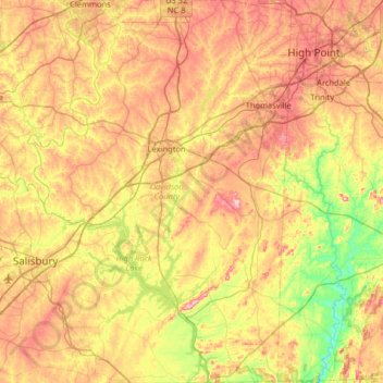
Nom : Carte topographique Davidson County, altitude, relief.
Lieu : Davidson County, Caroline du Nord, États-Unis d'Amérique (35.50416 -80.48759 36.02682 -80.04324)
Altitude moyenne : 222 m
Altitude minimum : 111 m
Altitude maximum : 352 m
Autres cartes topographiques
Cliquez sur une carte pour visualiser sa topographie, son altitude et son relief.
Appalaches
États-Unis d'Amérique > Caroline du Nord > Yancey County
La chaîne des Appalaches occupe dans sa plus grande partie le territoire américain et déborde sur le sud-est du Canada. Elle s'étend entre la latitude 49°N (monts Chic-Chocs au Québec, Canada) et la latitude 32°N (Alabama, États-Unis). Le point culminant de la partie canadienne du massif est le mont…
Altitude moyenne : 1’463 m
Clingmans Dome
États-Unis d'Amérique > Caroline du Nord > Swain County
Avec 2 025 mètres d'altitude, c'est le point culminant des monts Great Smoky et du Tennessee, de même que le plus haut sommet du Sentier des Appalaches.
Altitude moyenne : 1’716 m
Westwood
États-Unis d'Amérique > Caroline du Nord > Scotland County > Laurinburg
Altitude moyenne : 69 m
Greenbrier
États-Unis d'Amérique > Caroline du Nord > Comté d'Alamance > Burlington
Altitude moyenne : 189 m
Craven Terrace
États-Unis d'Amérique > Caroline du Nord > Craven County > New Bern
Altitude moyenne : 2 m
Appalaches
États-Unis d'Amérique > Caroline du Nord > Yancey County
La chaîne des Appalaches occupe dans sa plus grande partie le territoire américain et déborde sur le sud-est du Canada. Elle s'étend entre la latitude 49°N (monts Chic-Chocs au Québec, Canada) et la latitude 32°N (Alabama, États-Unis). Le point culminant de la partie canadienne du massif est le mont…
Altitude moyenne : 1’463 m
Hemby Bridge
États-Unis d'Amérique > Caroline du Nord > Union County > Indian Trail
Altitude moyenne : 197 m
Saint Mere Eglise
États-Unis d'Amérique > Caroline du Nord > Cumberland County
Altitude moyenne : 90 m
Somerset
États-Unis d'Amérique > Caroline du Nord > Person County > City of Roxboro > Somerset
Altitude moyenne : 200 m