
Carte topographique Scarborough
Carte interactive
Cliquez sur la carte pour afficher l’altitude.
À propos de cette carte
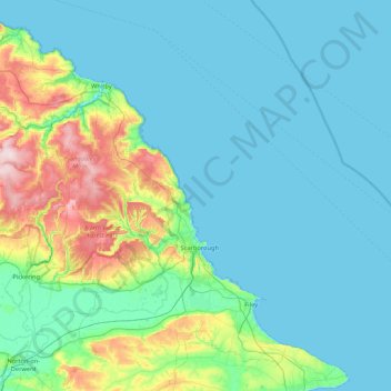
Nom : Carte topographique Scarborough, altitude, relief.
Lieu : Scarborough, North Yorkshire, Angleterre, Royaume-Uni (54.13242 -1.06468 54.56214 -0.21235)
Altitude moyenne : 50 m
Altitude minimum : 0 m
Altitude maximum : 323 m
Autres cartes topographiques
Cliquez sur une carte pour visualiser sa topographie, son altitude et son relief.
Whernside
Royaume-Uni > Angleterre > North Yorkshire > Ingleton
Whernside est un sommet du Royaume-Uni culminant à 736 mètres d'altitude dans la chaîne des Pennines, à la frontière entre les comtés du Yorkshire du Nord, dont il est le point culminant, et de Cumbria, dans le Nord de l'Angleterre. Il fait partie du parc national des Yorkshire Dales. C'est une…
Altitude moyenne : 533 m