Géolocaliser

Carte topographique Caniçal

Carte interactive

Cliquez sur la carte pour afficher l’altitude.

À propos de cette carte

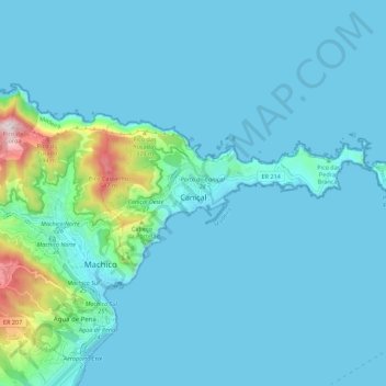
Nom : Carte topographique Caniçal, altitude, relief.

Lieu : Caniçal, Machico, Madeira, Portugal (32.72260 -16.76570 32.75762 -16.65525)

Altitude moyenne : 72 m

Altitude minimum : -1 m

Altitude maximum : 724 m

Caniçal borders the municipal seat of Machico on its western frontier, and is surrounded by the Atlantic Ocean on the remaining borders. The roughly escarped terrain is prominent in the western border, where altitudes reach 800 metres above sea level and ravines are semi-active or dry year round. The urbanized and residential lands are located in a semi-gently sloping central area, while to the eastern coast, the land extends into a long narrow isthmus at Ponta de São Lourenço. Although most of the mountainous western region is forested, most of the remaining areas of the parish are populated with smaller species of herbaceous bushes, trees and pasturelands, until the Ponta de São Lourenço where vegetation is limited to sparse low-lying grasses.

Wikipedia (CC-BY-SA 3.0)

Autres cartes topographiques

Cliquez sur une carte pour visualiser sa topographie, son altitude et son relief.

Miradouro de São Lourenço

Portugal > Machico > Caniçal

Miradouro de São Lourenço, Ponta de São Lourenco, Caniçal, Machico, Madeira, 9200-044, Portugal

Altitude moyenne : 14 m

Porto da Cruz

Portugal > Machico

Porto da Cruz, Machico, Madeira, Portugal

Altitude moyenne : 448 m