
Faire un don
Équipez-vous pour votre prochaine aventure :
En tant que Partenaire Amazon, ce site perçoit une commission sur les achats éligibles sans surcoût pour vous.
Carte topographique Dohan
Cliquez sur la carte pour afficher l’altitude.
Faire un don
Équipez-vous pour votre prochaine aventure :
En tant que Partenaire Amazon, ce site perçoit une commission sur les achats éligibles sans surcoût pour vous.
À propos de cette carte
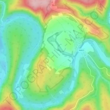
Nom : Carte topographique Dohan, altitude, relief.
Lieu : Dohan, Bouillon, Neufchâteau, Luxembourg, Wallonie, Belgique (49.77870 5.11528 49.80675 5.16091)
Altitude moyenne : 284 m
Altitude minimum : 220 m
Altitude maximum : 400 m
Faire un don
Équipez-vous pour votre prochaine aventure :
En tant que Partenaire Amazon, ce site perçoit une commission sur les achats éligibles sans surcoût pour vous.
Autres cartes topographiques
Cliquez sur une carte pour visualiser sa topographie, son altitude et son relief.
Bouillon
Belgique > Luxembourg > Neufchâteau > Bouillon
Entourée de forêts, la ville s’étend dans et autour d’un méandre accentué de la Semois, un affluent de la Meuse. L'altitude y est d'environ 220 mètres. Elle est desservie par la route nationale 83 menant à Arlon, route qui borde la ville à l’est et qui se confond sur le territoire communal avec…
Altitude moyenne : 338 m
Faire un don
Équipez-vous pour votre prochaine aventure :
En tant que Partenaire Amazon, ce site perçoit une commission sur les achats éligibles sans surcoût pour vous.
Le Tombeau du Géant
Belgique > Luxembourg > Neufchâteau > Bouillon > Botassart
Altitude moyenne : 300 m