Géolocaliser

Carte topographique Grande Prairie

Carte interactive

Cliquez sur la carte pour afficher l’altitude.

À propos de cette carte

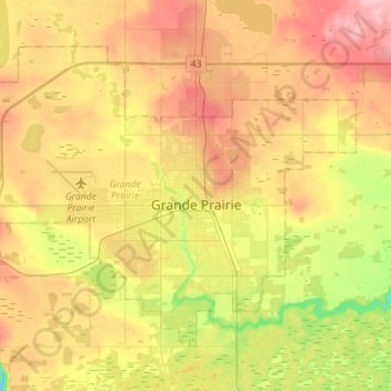
Nom : Carte topographique Grande Prairie, altitude, relief.

Lieu : Grande Prairie, Division No. 19, Alberta, Canada (55.11247 -118.96176 55.23618 -118.67955)

Altitude moyenne : 665 m

Altitude minimum : 600 m

Altitude maximum : 726 m

Grande Prairie is located just north of the 55th parallel north, and is 465 km (289 mi) northwest of Edmonton, lying at an elevation of 669 m (2,195 ft) above sea level. The city is surrounded by farmland to the north, east, and west. To the south lies a vast boreal forest with aspen, tamarack, lodgepole pine, jack pine, and black spruce extending well into the foothills of the Canadian Rockies south and southwest of the city.

Wikipedia (CC-BY-SA 3.0)

Autres cartes topographiques

Cliquez sur une carte pour visualiser sa topographie, son altitude et son relief.

Village of Hythe

Canada > Alberta > Division No. 19

Village of Hythe, Division No. 19, Alberta, Canada

Altitude moyenne : 746 m