
Faire un don
Équipez-vous pour votre prochaine aventure :
En tant que Partenaire Amazon, ce site perçoit une commission sur les achats éligibles sans surcoût pour vous.
Carte topographique Bihar
Cliquez sur la carte pour afficher l’altitude.
Faire un don
Équipez-vous pour votre prochaine aventure :
En tant que Partenaire Amazon, ce site perçoit une commission sur les achats éligibles sans surcoût pour vous.
À propos de cette carte
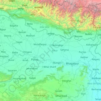
Nom : Carte topographique Bihar, altitude, relief.
Lieu : Bihar, Inde (24.28572 83.32126 27.52164 88.29823)
Altitude moyenne : 606 m
Altitude minimum : 11 m
Altitude maximum : 8’419 m
Faire un don
Équipez-vous pour votre prochaine aventure :
En tant que Partenaire Amazon, ce site perçoit une commission sur les achats éligibles sans surcoût pour vous.
Autres cartes topographiques
Cliquez sur une carte pour visualiser sa topographie, son altitude et son relief.
Faire un don
Équipez-vous pour votre prochaine aventure :
En tant que Partenaire Amazon, ce site perçoit une commission sur les achats éligibles sans surcoût pour vous.
Faire un don
Équipez-vous pour votre prochaine aventure :
En tant que Partenaire Amazon, ce site perçoit une commission sur les achats éligibles sans surcoût pour vous.
Mumbai
Bombay est située dans l'ouest de l'Inde, à l'embouchure du fleuve Ulhas, sur la côte occidentale du pays, appelée à cette latitude côte de Konkan. La ville, qui borde la mer d'Arabie, s'est développée sur l'île de Salsette, dont la partie nord appartient au district de Thane. L'altitude de la ville…
Altitude moyenne : 13 m
Faire un don
Équipez-vous pour votre prochaine aventure :
En tant que Partenaire Amazon, ce site perçoit une commission sur les achats éligibles sans surcoût pour vous.
Faire un don
Équipez-vous pour votre prochaine aventure :
En tant que Partenaire Amazon, ce site perçoit une commission sur les achats éligibles sans surcoût pour vous.
Pune
Inde > Maharashtra > Pune City Subdistrict
Pune se trouve à 120 km au sud-est de Bombay, à la confluence des rivières Mula et Mutha, sur le bord du plateau du Deccan dans la chaine des Ghats occidentaux, à 554 mètres d'altitude en moyenne. Le lac de retenue de Khadakwasla (en) au sud-ouest de la ville permet l'approvisionnement en eau.
Altitude moyenne : 641 m
Faire un don
Équipez-vous pour votre prochaine aventure :
En tant que Partenaire Amazon, ce site perçoit une commission sur les achats éligibles sans surcoût pour vous.
Delhi
Inde > Delhi > Kotwali Tehsil
L'arête de Delhi est un petit massif qui trouve son origine dans la chaîne des Aravalli et qui entoure les parties ouest, nord-est et nord-ouest de la ville. Elle atteint l'altitude de 318 m.
Altitude moyenne : 216 m
Gangotri
Inde > Uttarakhand > Bhatwari
Le site comporte un temple dédié à la déesse Ganga, à plus de 3 000 mètres d'altitude que surplombe une montagne de 6 614 mètres. On y trouve des bassins consacrés aux trois divinités de la trimūrti, Brahmā, Vishnou et Shiva, dans lesquels se baignent les dévots hindous.
Altitude moyenne : 4’139 m
Faire un don
Équipez-vous pour votre prochaine aventure :
En tant que Partenaire Amazon, ce site perçoit une commission sur les achats éligibles sans surcoût pour vous.
Faire un don
Équipez-vous pour votre prochaine aventure :
En tant que Partenaire Amazon, ce site perçoit une commission sur les achats éligibles sans surcoût pour vous.
Dharamsala
Inde > Himachal Pradesh > Dharamshala
La ville s'étend sur 27,6 km2 à une altitude moyenne de 1 457 mètres. L'agglomération se divise en deux parties.
Altitude moyenne : 1’781 m
Faire un don
Équipez-vous pour votre prochaine aventure :
En tant que Partenaire Amazon, ce site perçoit une commission sur les achats éligibles sans surcoût pour vous.
Udhagamandalam
Inde > Tamil Nadu > Udhagamandalam
Cette station climatique à 2 250 m d'altitude fut fondée au début du XIX siècle pour accueillir le gouvernement de Madras qui voulait prendre le frais en été. Auparavant, cette région était uniquement habitée par les Todas, peuple tribal vouant une adoration toute particulière aux buffles. La ville…
Altitude moyenne : 2’234 m
Faire un don
Équipez-vous pour votre prochaine aventure :
En tant que Partenaire Amazon, ce site perçoit une commission sur les achats éligibles sans surcoût pour vous.
Mumbai
Bombay est située dans l'ouest de l'Inde, à l'embouchure du fleuve Ulhas, sur la côte occidentale du pays, appelée à cette latitude côte de Konkan. La ville, qui borde la mer d'Arabie, s'est développée sur l'île de Salsette, dont la partie nord appartient au district de Thane. L'altitude de la ville…
Altitude moyenne : 13 m
Faire un don
Équipez-vous pour votre prochaine aventure :
En tant que Partenaire Amazon, ce site perçoit une commission sur les achats éligibles sans surcoût pour vous.
Faire un don
Équipez-vous pour votre prochaine aventure :
En tant que Partenaire Amazon, ce site perçoit une commission sur les achats éligibles sans surcoût pour vous.
Faire un don
Équipez-vous pour votre prochaine aventure :
En tant que Partenaire Amazon, ce site perçoit une commission sur les achats éligibles sans surcoût pour vous.
Faire un don
Équipez-vous pour votre prochaine aventure :
En tant que Partenaire Amazon, ce site perçoit une commission sur les achats éligibles sans surcoût pour vous.
Faire un don
Équipez-vous pour votre prochaine aventure :
En tant que Partenaire Amazon, ce site perçoit une commission sur les achats éligibles sans surcoût pour vous.
Faire un don
Équipez-vous pour votre prochaine aventure :
En tant que Partenaire Amazon, ce site perçoit une commission sur les achats éligibles sans surcoût pour vous.
Faire un don
Équipez-vous pour votre prochaine aventure :
En tant que Partenaire Amazon, ce site perçoit une commission sur les achats éligibles sans surcoût pour vous.
Faire un don
Équipez-vous pour votre prochaine aventure :
En tant que Partenaire Amazon, ce site perçoit une commission sur les achats éligibles sans surcoût pour vous.
Faire un don
Équipez-vous pour votre prochaine aventure :
En tant que Partenaire Amazon, ce site perçoit une commission sur les achats éligibles sans surcoût pour vous.
Faire un don
Équipez-vous pour votre prochaine aventure :
En tant que Partenaire Amazon, ce site perçoit une commission sur les achats éligibles sans surcoût pour vous.
Kaza
Inde > Himachal Pradesh > Spiti
La ville de Kaza, Kaze ou Kaja est une subdivision de la vallée de Spiti dans le district de Lahaul et Spiti dans l’État de l'Himachal Pradesh, dans l'Ouest de l'Himalaya en Inde. Spiti, qui est une partie du district de Lahaul et Spiti dans l'Himachal, est une région froide de haute altitude ayant…
Altitude moyenne : 4’161 m
Faire un don
Équipez-vous pour votre prochaine aventure :
En tant que Partenaire Amazon, ce site perçoit une commission sur les achats éligibles sans surcoût pour vous.
Dharamsala
Inde > Himachal Pradesh > Dharamshala
La ville s'étend sur 27,6 km2 à une altitude moyenne de 1 457 mètres. L'agglomération se divise en deux parties.
Altitude moyenne : 1’781 m
Faire un don
Équipez-vous pour votre prochaine aventure :
En tant que Partenaire Amazon, ce site perçoit une commission sur les achats éligibles sans surcoût pour vous.
Jaipur
Inde > Rajasthan > Jaipur Tehsil
Jaipur se trouve à 430 m d’altitude et à 260 km de Delhi, dans une cuvette protégée par la chaîne des Aravalli.
Altitude moyenne : 408 m
Faire un don
Équipez-vous pour votre prochaine aventure :
En tant que Partenaire Amazon, ce site perçoit une commission sur les achats éligibles sans surcoût pour vous.
Mawsynram
Mawsynram est un tehsil de l'État du Meghalaya, situé à l'extrémité ouest du district des East Khasi Hills en Inde et à 56 kilomètres de Shillong, la capitale de l'Etat. Il est réputé pour recevoir le plus de précipitations au monde, car les monts Khasi font barrière à la mousson venant du golfe du…
Altitude moyenne : 1’028 m
Faire un don
Équipez-vous pour votre prochaine aventure :
En tant que Partenaire Amazon, ce site perçoit une commission sur les achats éligibles sans surcoût pour vous.
Faire un don
Équipez-vous pour votre prochaine aventure :
En tant que Partenaire Amazon, ce site perçoit une commission sur les achats éligibles sans surcoût pour vous.
Faire un don
Équipez-vous pour votre prochaine aventure :
En tant que Partenaire Amazon, ce site perçoit une commission sur les achats éligibles sans surcoût pour vous.