
Carte topographique Lac Michigan
Carte interactive
Cliquez sur la carte pour afficher l’altitude.
À propos de cette carte
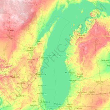
Nom : Carte topographique Lac Michigan, altitude, relief.
Lieu : Lac Michigan, Oceana, Michigan, États-Unis d'Amérique (41.60888 -88.04169 46.10229 -84.75208)
Altitude moyenne : 260 m
Altitude minimum : 169 m
Altitude maximum : 582 m
Autres cartes topographiques
Cliquez sur une carte pour visualiser sa topographie, son altitude et son relief.
Centerville Township
États-Unis d'Amérique > Michigan > Leelanau County
Centerville Township, Leelanau County, Michigan, 49621, États-Unis d'Amérique
Altitude moyenne : 221 m
Pontiac
États-Unis d'Amérique > Michigan > Oakland County
Pontiac, Oakland County, Michigan, États-Unis d'Amérique
Altitude moyenne : 290 m
Oceola Township
États-Unis d'Amérique > Michigan > Oceola Township
Oceola Township, Livingston County, Michigan, 48855, États-Unis d'Amérique
Altitude moyenne : 294 m
Alcona County
États-Unis d'Amérique > Michigan
Alcona County, Michigan, États-Unis d'Amérique
Altitude moyenne : 249 m
Tonawanda Lake
États-Unis d'Amérique > Michigan > Interlochen
Tonawanda Lake, Tonawanda Road, Interlochen, Grand Traverse County, Michigan, 49637, États-Unis d'Amérique
Altitude moyenne : 258 m
Parc national de l'Isle Royale
États-Unis d'Amérique > Michigan
Parc national de l'Isle Royale, Greenstone Ridge Trail, Houghton Township, Keweenaw County, Michigan, États-Unis d'Amérique
Altitude moyenne : 189 m
Portage Lake
États-Unis d'Amérique > Michigan > Senter
Portage Lake, East Grosse Pointe Shores Road, Senter, Houghton County, Michigan, 49922, États-Unis d'Amérique
Altitude moyenne : 212 m