
Carte topographique Boyolali
Carte interactive
Cliquez sur la carte pour afficher l’altitude.
À propos de cette carte
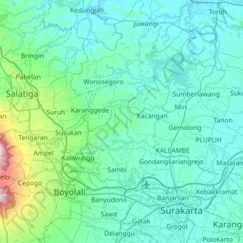
Nom : Carte topographique Boyolali, altitude, relief.
Lieu : Boyolali, Java central, Indonésie (-7.63505 110.38006 -7.13913 110.85878)
Altitude moyenne : 277 m
Altitude minimum : 25 m
Altitude maximum : 2’555 m
Autres cartes topographiques
Cliquez sur une carte pour visualiser sa topographie, son altitude et son relief.
Mojosongo
Indonésie > Java central > Boyolali
Mojosongo, Boyolali, Java central, Jawa, 57322, Indonésie
Altitude moyenne : 318 m
Karangtempel
Indonésie > Java central > Semarang
Karangtempel, Semarang Timur, Semarang, Java central, 50125, Indonésie
Altitude moyenne : 9 m
Karanganyar
Karanganyar, Java central, Jawa, Indonésie
Altitude moyenne : 408 m
Lingk. Patran
Indonésie > Java central > Lingk. Patran
Lingk. Patran, Magelang, Java central, 56511, Indonésie
Altitude moyenne : 252 m
Purwokerto
Indonésie > Java central > Purwokerto
Purwokerto, Banyumas, Java central, 53116, Indonésie
Altitude moyenne : 277 m
Bulusan
Indonésie > Java central > Semarang
Bulusan, Tembalang, Semarang, Java central, 50277, Indonésie
Altitude moyenne : 140 m
Gunung Lawu
Indonésie > Java central > Gondosuli
Gunung Lawu, Gunung Lawu Track, Gondosuli, Karanganyar, Java central, Indonésie
Altitude moyenne : 2’881 m
Telomoyo
Indonésie > Java central > Salatiga
Telomoyo, Salatiga, Java central, 56194, Indonésie
Altitude moyenne : 1’386 m
Puncak Trianggulasi
Indonésie > Java central > Jrakah
Puncak Trianggulasi, Jrakah, Java central, Indonésie
Altitude moyenne : 2’696 m
Karanganyar
Indonésie > Java central > Semarang
Karanganyar, Tugu, Semarang, Java central, Indonésie
Altitude moyenne : 7 m
Wonosobo
Indonésie > Java central > Wonosobo
Wonosobo, Java central, 56311, Indonésie
Altitude moyenne : 776 m
Gunung Sindoro
Indonésie > Java central > Magelang
Gunung Sindoro, Magelang, Java central, Indonésie
Altitude moyenne : 2’572 m
Boyolali
Indonésie > Java central > Boyolali
Boyolali, Java central, 57311, Indonésie
Altitude moyenne : 403 m