Géolocaliser

Carte topographique Kreuzberg

Carte interactive

Cliquez sur la carte pour afficher l’altitude.

À propos de cette carte

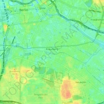
Nom : Carte topographique Kreuzberg, altitude, relief.

Lieu : Kreuzberg, Friedrichshain-Kreuzberg, Berlin, Germany (52.48279 13.36823 52.50938 13.45293)

Altitude moyenne : 43 m

Altitude minimum : 29 m

Altitude maximum : 67 m

In contrast to many other areas of Berlin, which were villages before their integration into Berlin, Kreuzberg has a rather short history. It was formed on 1 October 1920 by the Greater Berlin Act providing for the incorporation of suburbs and the reorganisation of Berlin into twenty boroughs. The eastern Friedrichsvorstadt, the southern Friedrichstadt, the western and southern Luisenstadt and the Tempelhofer Vorstadt were merged into the new VIth borough of Berlin, first named Hallesches Tor. On 27 September 1921 the borough assembly of Hallesches Tor decided to rename the borough after the homonymous hill. Kreuzberg, literally meaning cross hill, is the point of the highest elevation in the Kreuzberg locality, which is 66 m (217 ft) above sea level. The hill is traditionally a place for weekend trips. It received its name from the 1821 Prussian National Monument for the Liberation Wars by Karl Friedrich Schinkel within the Viktoriapark, built in commemoration of the Napoleonic Wars. Except for its northernmost part, the quarter Friedrichstadt (established at the end of the 17th century), today's "Kreuzberg" was a very rural place until well into the 19th century.

Autres cartes topographiques

Cliquez sur une carte pour visualiser sa topographie, son altitude et son relief.

Berlin

Germany > Berlin > Berlin

Berlin, 10117, Germany

Altitude moyenne : 47 m

Köpenick

Germany > Berlin

Köpenick, Treptow-Köpenick, Berlin, Germany

Altitude moyenne : 39 m