
Faire un don
Équipez-vous pour votre prochaine aventure :
En tant que Partenaire Amazon, ce site perçoit une commission sur les achats éligibles sans surcoût pour vous.
Carte topographique Running Springs
Cliquez sur la carte pour afficher l’altitude.
Faire un don
Équipez-vous pour votre prochaine aventure :
En tant que Partenaire Amazon, ce site perçoit une commission sur les achats éligibles sans surcoût pour vous.
À propos de cette carte
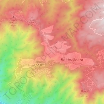
Nom : Carte topographique Running Springs, altitude, relief.
Altitude moyenne : 1’656 m
Altitude minimum : 875 m
Altitude maximum : 2’157 m
Faire un don
Équipez-vous pour votre prochaine aventure :
En tant que Partenaire Amazon, ce site perçoit une commission sur les achats éligibles sans surcoût pour vous.
Autres cartes topographiques
Cliquez sur une carte pour visualiser sa topographie, son altitude et son relief.
Barstow
États-Unis d'Amérique > Californie > San Bernardino County
Le climat à Barstow est désertique mais les températures diurnes ne sont pas aussi élevées que dans la vallée de la mort voisine ou à Baker en raison de l'altitude.
Altitude moyenne : 770 m
Faire un don
Équipez-vous pour votre prochaine aventure :
En tant que Partenaire Amazon, ce site perçoit une commission sur les achats éligibles sans surcoût pour vous.
Big Bear City
États-Unis d'Amérique > Californie > San Bernardino County > Big Bear City
Altitude moyenne : 2’214 m
San Bernardino National Forest
États-Unis d'Amérique > Californie > San Bernardino County
Altitude moyenne : 1’009 m
Faire un don
Équipez-vous pour votre prochaine aventure :
En tant que Partenaire Amazon, ce site perçoit une commission sur les achats éligibles sans surcoût pour vous.
Faire un don
Équipez-vous pour votre prochaine aventure :
En tant que Partenaire Amazon, ce site perçoit une commission sur les achats éligibles sans surcoût pour vous.
Fortynine Palms Oasis Spring
États-Unis d'Amérique > Californie > San Bernardino County
Altitude moyenne : 1’028 m
Chino Hills
États-Unis d'Amérique > Californie > San Bernardino County > Chino Hills
Altitude moyenne : 255 m
Faire un don
Équipez-vous pour votre prochaine aventure :
En tant que Partenaire Amazon, ce site perçoit une commission sur les achats éligibles sans surcoût pour vous.