
Carte topographique Vladivostok
Carte interactive
Cliquez sur la carte pour afficher l’altitude.
Vladivostok
Le point culminant est le mont Kholodilnik, son altitude s'élève à 257 m. Le mont du Nid d'aigle est souvent considéré comme le point culminant de la ville, mais avec une altitude de 199 m (214 m selon d'autres sources), c'est seulement le point le plus élevé du centre-ville, pas de l'agglomération tout entière.
À propos de cette carte
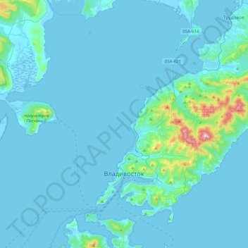
Nom : Carte topographique Vladivostok, altitude, relief.
Altitude moyenne : 29 m
Altitude minimum : -3 m
Altitude maximum : 450 m