
Faire un don
Équipez-vous pour votre prochaine aventure :
En tant que Partenaire Amazon, ce site perçoit une commission sur les achats éligibles sans surcoût pour vous.
Carte topographique Bogâltin
Cliquez sur la carte pour afficher l’altitude.
Faire un don
Équipez-vous pour votre prochaine aventure :
En tant que Partenaire Amazon, ce site perçoit une commission sur les achats éligibles sans surcoût pour vous.
À propos de cette carte
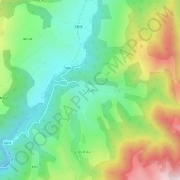
Nom : Carte topographique Bogâltin, altitude, relief.
Lieu : Bogâltin, Cornereva, Caraș-Severin, 327112, Romania (45.01905 22.39492 45.05905 22.43492)
Altitude moyenne : 747 m
Altitude minimum : 422 m
Altitude maximum : 1’338 m
Faire un don
Équipez-vous pour votre prochaine aventure :
En tant que Partenaire Amazon, ce site perçoit une commission sur les achats éligibles sans surcoût pour vous.
Autres cartes topographiques
Cliquez sur une carte pour visualiser sa topographie, son altitude et son relief.
Mehadia
Mehadia is located in southwestern Romania in the Cerna valley at an elevation of 287 m (942 ft). It is located along European route E70, south of the village of Plugova and north of Topleț. Beyond Topleț to the south is Orșova, which was for many years the residence of a Pasha and contained a prominent…
Altitude moyenne : 613 m
Faire un don
Équipez-vous pour votre prochaine aventure :
En tant que Partenaire Amazon, ce site perçoit une commission sur les achats éligibles sans surcoût pour vous.
Băile Herculane
Băile Herculane (Latin: Aqua Herculis; German: Herkulesbad; Hungarian: Herkulesfürdő; Czech: Herkulovy Lázně, Turkish: Lazarethane) is a spa town in Romanian Banat, in Caraș-Severin County, situated in the valley of the Cerna River, between the Mehedinți Mountains to the east and the Cerna Mountains to…
Altitude moyenne : 571 m
Faire un don
Équipez-vous pour votre prochaine aventure :
En tant que Partenaire Amazon, ce site perçoit une commission sur les achats éligibles sans surcoût pour vous.
Faire un don
Équipez-vous pour votre prochaine aventure :
En tant que Partenaire Amazon, ce site perçoit une commission sur les achats éligibles sans surcoût pour vous.
Teregova
The commune is located in the east-central part of county, stretching eastwards to the border with Hunedoara County. It is situated at an altitude of 424 m (1,391 ft), at the foot of the Țarcu Mountains. The river Timiș flows through Rusca village; its right tributary, the river Teregova, joins the Timiș in…
Altitude moyenne : 803 m
Faire un don
Équipez-vous pour votre prochaine aventure :
En tant que Partenaire Amazon, ce site perçoit une commission sur les achats éligibles sans surcoût pour vous.
Faire un don
Équipez-vous pour votre prochaine aventure :
En tant que Partenaire Amazon, ce site perçoit une commission sur les achats éligibles sans surcoût pour vous.
Faire un don
Équipez-vous pour votre prochaine aventure :
En tant que Partenaire Amazon, ce site perçoit une commission sur les achats éligibles sans surcoût pour vous.
Faire un don
Équipez-vous pour votre prochaine aventure :
En tant que Partenaire Amazon, ce site perçoit une commission sur les achats éligibles sans surcoût pour vous.
Faire un don
Équipez-vous pour votre prochaine aventure :
En tant que Partenaire Amazon, ce site perçoit une commission sur les achats éligibles sans surcoût pour vous.